.png)

AI Summary
Since launching Geospatial Projects in beta, we've been rapidly iterating based on feedback from our community of defense contractors, agricultural monitoring teams, and remote sensing specialists. Today, we're excited to announce our latest updates that introduce cloud storage integration, performance optimizations for massive datasets, and enhanced navigation capabilities that directly address the most pressing needs of geospatial machine learning workflows.
Cloud Storage Integration: Seamless Dataset Management
Our most significant addition is native cloud storage support for AWS, Azure, and Google Cloud Platform buckets. This feature eliminates the traditional bottleneck of manual file uploads for large geospatial datasets, addressing one of the key challenges in satellite imagery annotation.
What We've Built:
- Automatic synchronization of Cloud Optimized GeoTIFF (COG) files from connected buckets
- Support for EPSG:4326 and EPSG:3857 coordinate reference systems
- Real-time asset addition as new files are detected in your bucket
We designed this integration specifically for teams working with satellite imagery pipelines where hundreds of gigabytes of imagery are generated regularly. Rather than managing individual file uploads, you can now point your processing pipelines directly to cloud storage and have assets automatically appear in your annotation projects.
Impact on Your Workflow: For ML engineers building computer vision models on geospatial data, this means your annotation projects can scale seamlessly with data acquisition. Whether you're processing daily satellite passes or seasonal agricultural surveys, our cloud integration ensures your annotation pipeline remains synchronized with your data collection workflow.
Advanced Visualization and Performance Optimizations
Intelligent Image Rescaling
We've implemented automatic rescaling for non-UInt8 format images using 2nd and 98th percentile pixel values. This statistical approach ensures optimal visualization across diverse sensor types and bit depths without requiring manual histogram adjustment—a critical feature for satellite imagery annotation where different spectral bands require different visualization parameters.
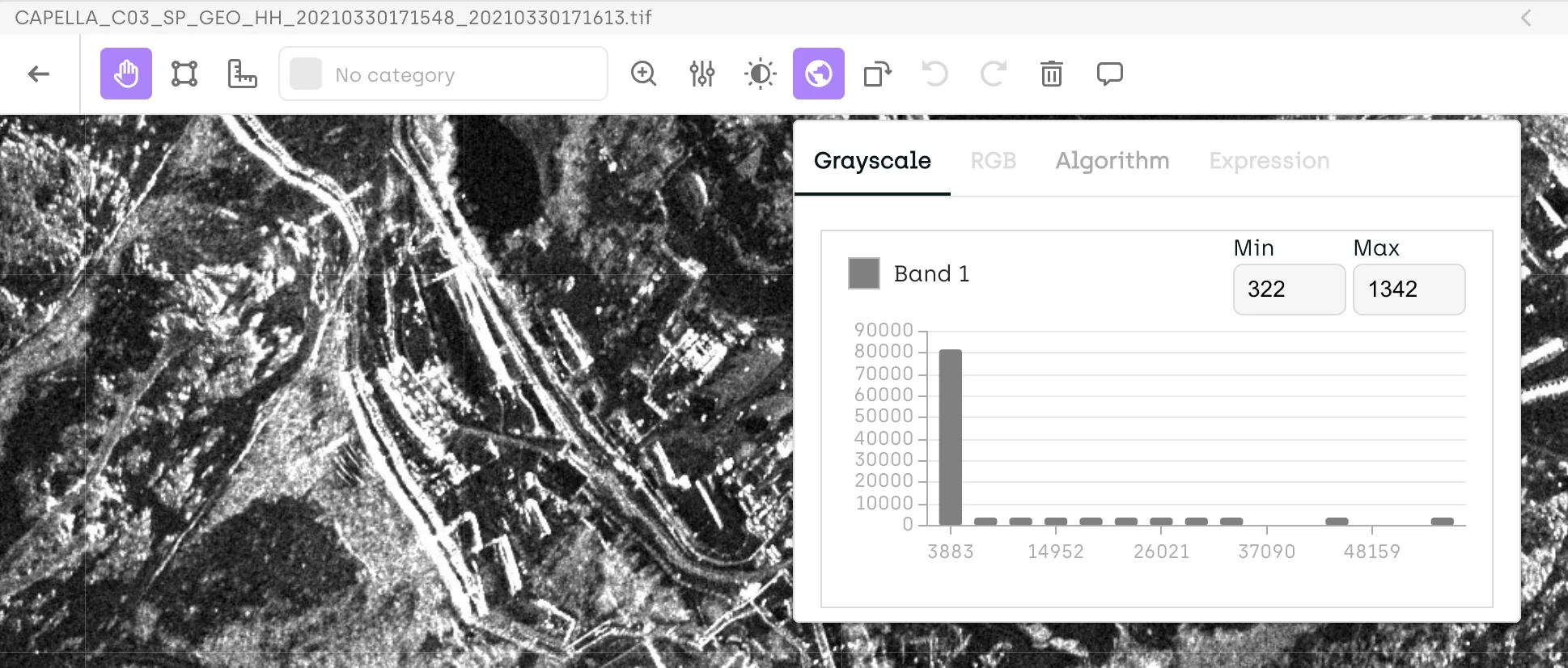
Our new histogram visualization shows per-band pixel value distribution, enabling your annotators to understand data characteristics and make informed decisions about band combinations for specific annotation tasks. This builds on our existing multispectral data processing capabilities that preserve all spectral bands during import.
Performance at Scale
We've engineered our platform to handle extremely dense annotations—supporting segmentation labels with over 10,000 objects without performance degradation. This capability addresses applications like urban planning annotations, forest inventory mapping, or detailed infrastructure analysis where individual objects might number in the tens of thousands per image.
For ML teams training object detection or instance segmentation models on high-resolution imagery, this means your annotation projects can scale to match the granularity required for production model performance.
Enhanced Navigation and Spatial Context
Coordinate-Based Navigation

We've added a "Find location" feature that allows direct navigation to specific coordinates via the right-click context menu. Users can input latitude and longitude coordinates to instantly jump to precise locations within large imagery.
This feature streamlines validation workflows where ground truth coordinates are available, supporting teams following geospatial annotation best practices that require spatial accuracy and consistency.
Interactive Mini-Map Improvements
Our mini-map now supports interactive navigation through viewport dragging, providing intuitive spatial orientation within large scenes. This enhancement addresses a common challenge we've observed in geospatial annotation where annotators can lose spatial context when working at high zoom levels on extensive imagery.
This improvement builds on our foundational geospatial imagery annotation capabilities that include precise geo-referencing and metadata preservation.
Multi-Step Workflow Enhancements
While still in private beta, we've added several enterprise-focused features to our multi-step workflow system:
Priority-Based Review Queues: We now allow assets to be assigned priority levels for review, both through our interface and SDK, enabling teams to optimize annotation throughput based on model training schedules or project deadlines.
Customizable Step Names: Workflow steps can be renamed to match your organizational terminology, improving team adoption and process clarity.
SDK-Driven Label Corrections: Our SDK now supports targeted label corrections within specific workflow steps, enabling automated quality assurance processes and programmatic annotation refinement.
Technical Architecture Improvements
We've continued to mature our underlying COG processing architecture with several performance optimizations:
- Dynamic tile generation remains optimized for on-the-fly rendering
- Support for files up to 5GB per asset maintains our advantage over traditional image projects
- All spectral bands are preserved during import, enabling flexible band combination workflows
These improvements strengthen our commitment to providing enterprise geospatial annotation capabilities that meet the demands of production workflows.
Get Started
Geospatial Projects are currently available in beta upon request. We'd love to discuss how these enhanced capabilities could support your specific geospatial workflows and explore how Geospatial Projects can add value to your organization's data annotation needs.

_logo%201.svg)


.webp)