.png)

_logo%201.svg)


AI Summary
Best Geospatial Annotation Tool in 2025: Open-Source Options and Enterprise Solutions
The quality of annotated data directly impacts the success of machine learning models, computer vision applications, and automated feature extraction in geospatial analysis. Geospatial annotation services are crucial across various industries, such as agriculture, urban development, and environmental conservation, as they provide tailored solutions to meet specific industry needs. Choosing the right geospatial image annotation tool is crucial for project success for geospatial data scientists and GIS professionals working with satellite imagery, aerial photographs, and other remote sensing data.
This article examines the top geospatial imagery annotation tools available in 2025, focusing on open-source options and highlighting how enterprise solutions like Kili Technology address the limitations of open-source tools for organizations with enterprise-scale requirements.
Introduction to Geospatial Annotation
Geospatial annotation is the process of adding labels or annotations to geospatial data, such as satellite or aerial images, to provide context and meaning to the data. This process is essential for various applications, including environmental monitoring, disaster response, and urban planning. By annotating geospatial data, researchers and professionals can transform raw imagery into actionable insights, enabling more informed decision-making and analysis.
What is Geospatial Annotation?
Geospatial annotation involves assigning specific, descriptive tags to raw satellite or aerial imagery. This includes labels like ‘water,’ ‘forest,’ or more detailed labels like ‘deciduous forest’ or ‘flooded region.’ Geospatial annotation converts complex data into an easily understandable and analyzable form, enabling researchers and scientists to quickly understand and use remote sensing data. By providing clear and precise labels, geospatial annotation helps in identifying patterns, monitoring changes, and conducting detailed analyses of geographical features.
Challenges in Geospatial Image Annotation
Geospatial image annotation faces several significant challenges. The complexity of interpreting raw geospatial data for labeling purposes requires specialized knowledge and tools to accurately identify and classify features across diverse geographical contexts. Additionally, geospatial projects typically require a collaborative framework where team members can operate at scale (label, track progress, and implement quality rules and processes) in a streamlined workflow. Without proper collaboration tools, ensuring consistency and quality of annotations across different annotators becomes highly challenging, leading to potential errors in analysis and model training. Furthermore, maintaining spatial accuracy and proper geo-referencing throughout the annotation process presents technical hurdles that generic annotation tools often cannot address.
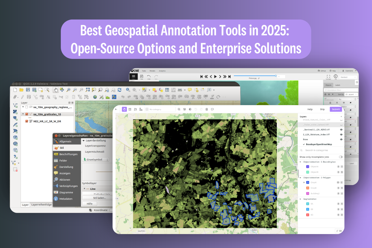
Open-Source Geospatial Annotation Tools: Capabilities and Limitations
Photo taken from Wikimedia.
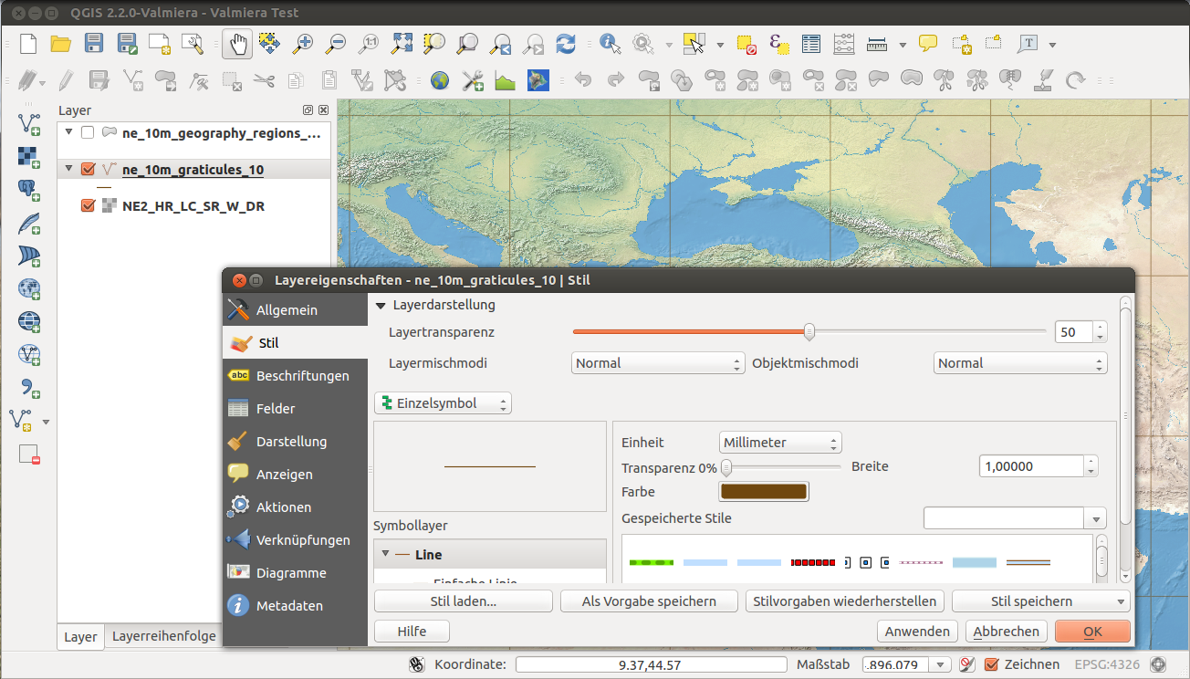
QGIS
QGIS remains the most versatile open-source GIS software with robust annotation capabilities. Its strengths include:
- Comprehensive support for various geospatial data formats
- Extensive editing tools for labeling and annotating geospatial data
- Large community support and regular updates
- Free availability, making it cost-effective for small teams
However, QGIS presents several challenges for enterprise-scale annotation projects:
- Steep learning curve requiring significant time investment
- Limited automation capabilities compared to commercial solutions
- Performance issues when handling large datasets
- Minimal specialized annotation workflows for machine learning preparation
- Lacks collaborative framework for team-based annotation, making it difficult to tackle scalability challenges
- Quality control is challenging without built-in mechanisms for verifying annotation accuracy across a team
- No centralized management for annotation guidelines and standards
CVAT (Computer Vision Annotation Tool)
CVAT is a powerful, open-source annotation tool developed by Intel, supporting various computer vision tasks. While it's not natively designed for geospatial data, it is sometimes used for geospatial projects due to its collaborative features:
- Designed to handle large-scale annotation projects with collaborative capabilities
- Supports multiple annotators working on the same project simultaneously
- Provides robust features for different annotation types like bounding boxes, polygons, and masks
However, CVAT has significant limitations for geospatial applications:
- Does not natively support geospatial imagery file formats such as GeoTIFF
- Lacks integration with geographic coordinate systems and projections
- Cannot maintain geospatial metadata and geo-referencing
- No support for multi-spectral imagery common in remote sensing applications
- Limited tools for distance measurements and coordinate precision needed for geospatial analysis
- Requires custom workarounds to handle geospatial data properly
Enterprise Needs in Geospatial Annotation
For organizations working with large-scale geospatial data, particularly in fields like defense, environmental monitoring, precision agriculture, and urban planning, enterprise-grade annotation solutions provide critical advantages over open-source alternatives.
Kili Technology: Advanced Geospatial Annotation for Enterprise Applications
Kili Technology's geospatial annotation platform addresses the limitations of open-source tools while delivering specialized features tailored to geospatial data scientists.
Advanced Annotation Capabilities
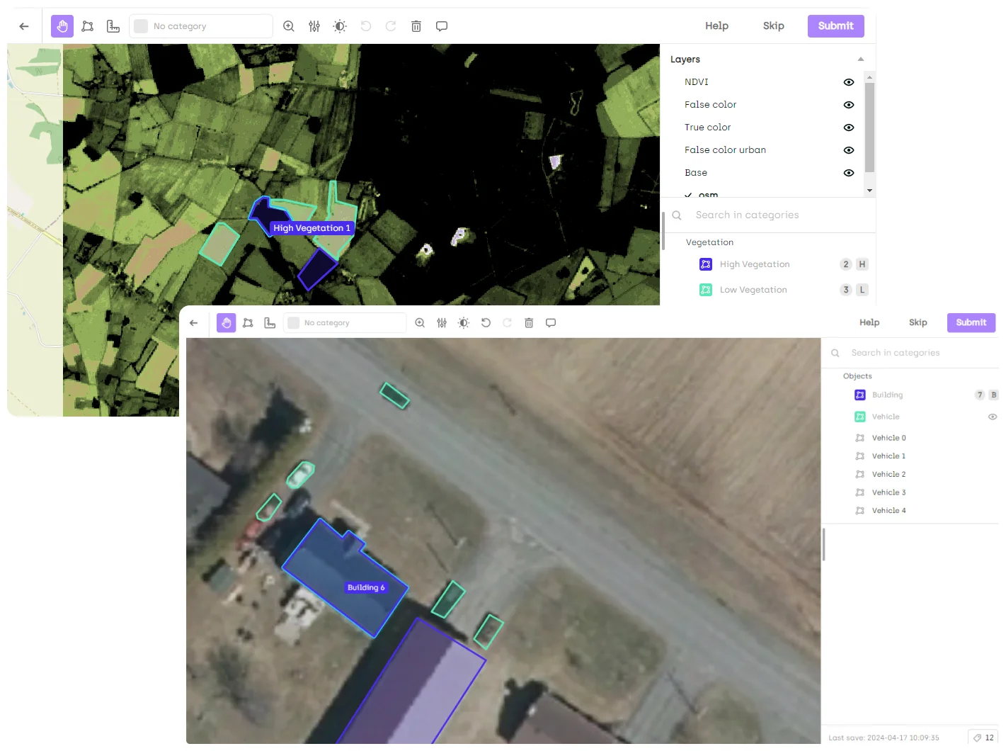
- Multi-format support: Native handling of GeoTiff, Tiff, JP2, and NITF formats with seamless integration across different coordinate reference systems
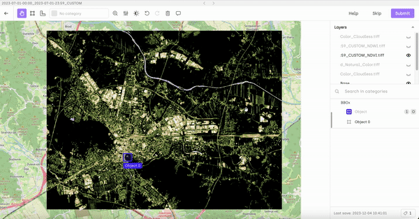
- Multi-spectral layering: Advanced analysis capabilities for beyond-RGB imagery, including infrared, thermal, and hyperspectral data critical for applications like vegetation health assessment and material identification
- Precise geo-referencing: Annotations maintain spatial accuracy with embedded metadata, ensuring real-world coordinate precision
Specialized Geospatial Tools
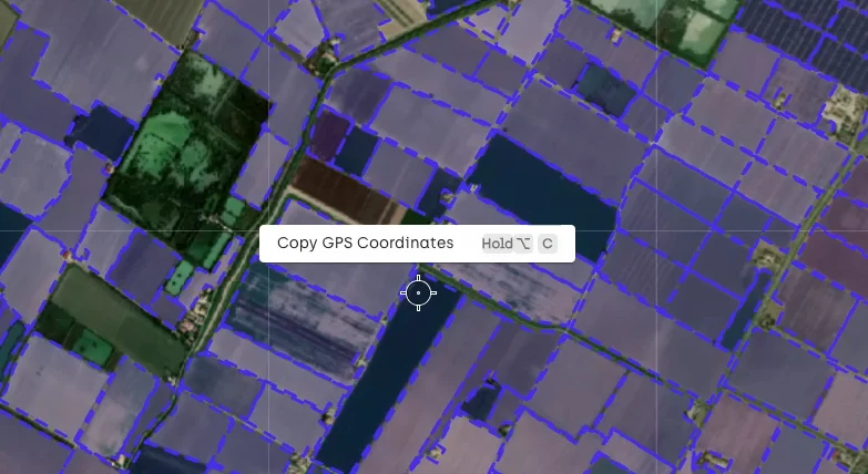
- GPS coordinate precision: One-click copying of exact coordinates, enabling meticulous documentation and cross-referencing
- Distance measurement: Built-in tools for detailed distance analysis in meters or feet, crucial for infrastructure planning and environmental assessment
- Slippy maps: Smooth navigation through large datasets with responsive zooming and panning without performance degradation
- Automated tiling: Intelligent division of large GeoTIFF files to enable efficient annotation workflows even with massive imagery datasets
Performance Optimization for Large Datasets
- Lazy loading: Optimized performance for images with over 1,000 annotations, reducing memory consumption and improving responsiveness
- Frictionless importing: Accelerated processing of geospatial data requiring tiling of converting compared to conventional approaches
- Optimized rendering: Intelligent handling of high-resolution satellite and aerial imagery ensuring smooth visualization across diverse hardware configurations
Advanced Quality Control Features
Kili enhances the value of geospatial data annotation by fostering seamless collaboration among large teams. The platform streamlines the workflow between labeling and reviewing, enabling smooth coordination between different user profiles, such as Subject Matter Experts and Annotators. This collaborative approach ensures that teams can work together effectively, producing high-quality training datasets with the right level of accuracy and expertise.
- Human-in-the-loop verification: Structured expert review processes to refine annotations, particularly valuable for complex feature identification
- Quality metrics: Easy implementation of quality control samples and comprehensive metrics to ensure annotation accuracy
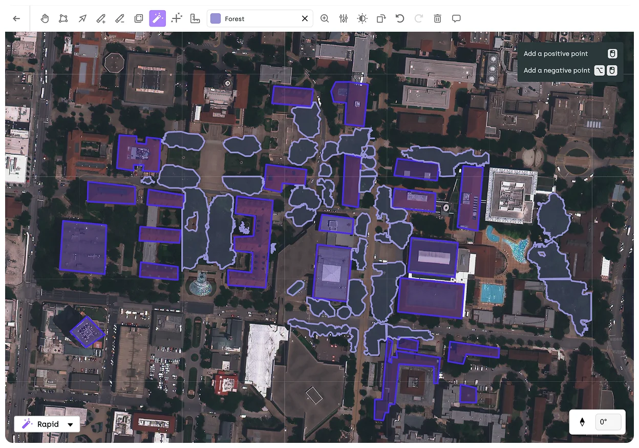
AI-Powered Efficiency
- AI-assisted annotation: Streamlined labeling with machine learning assistance, reducing manual work significantly
- Automated predictions: Support for Segment Anything Model 2 (SAM2) or custom models (BYOM) to accelerate annotation workflows
- Active learning: Intelligent model assistance that improves accuracy while requiring less initial training data
Enterprise Integration
- GIS system compatibility: Seamless integration with various coordinate reference systems and projection standards
- Cloud storage integration: Direct connections to major cloud platforms like AWS S3, Google Cloud Storage, and Microsoft Azure
- Export flexibility: Annotations exported with embedded longitude and latitude, keeping data GIS-ready for downstream applications
- API and SDK access: Robust programmatic access to core functionalities for custom workflow integration
Earth Observation and Remote Sensing Data Labeling
Geospatial annotation tools need specialized capabilities to handle the unique challenges of earth observation data. Kili Technology's platform is specifically optimized for:
Satellite Imagery Annotation
- Multi-resolution handling: Seamless annotation across varying spatial resolutions from low-resolution (30m+) to very high-resolution (<1m) satellite data
- Spectral band management: Support for RGB, NIR, SWIR, thermal, and other specialized band combinations essential for comprehensive earth observation analysis
- Global coverage support: Handling large-scale satellite imagery collections spanning diverse geographic regions with consistent annotation standards
Aerial and Drone Imagery Processing
- Terrain variation adaptation and flight path consistency: Through accurate geo-referencing and meticulous coordinate management, users can maintain annotation integrity despite perspective distortions and inconsistent image acquisition, ensuring reliable data for critical applications.
Use Cases for Kili Technology's Geospatial Annotation Platform
Defense Intelligence: Earth Observation for Security Applications
The defense and intelligence sector relies heavily on earth observation data analysis, where annotation quality directly impacts national security outcomes. Kili Technology's advanced annotation capabilities enable:
- Multi-sensor fusion annotation: Creating consistent labels across optical, SAR, and other sensor data for comprehensive intelligence products
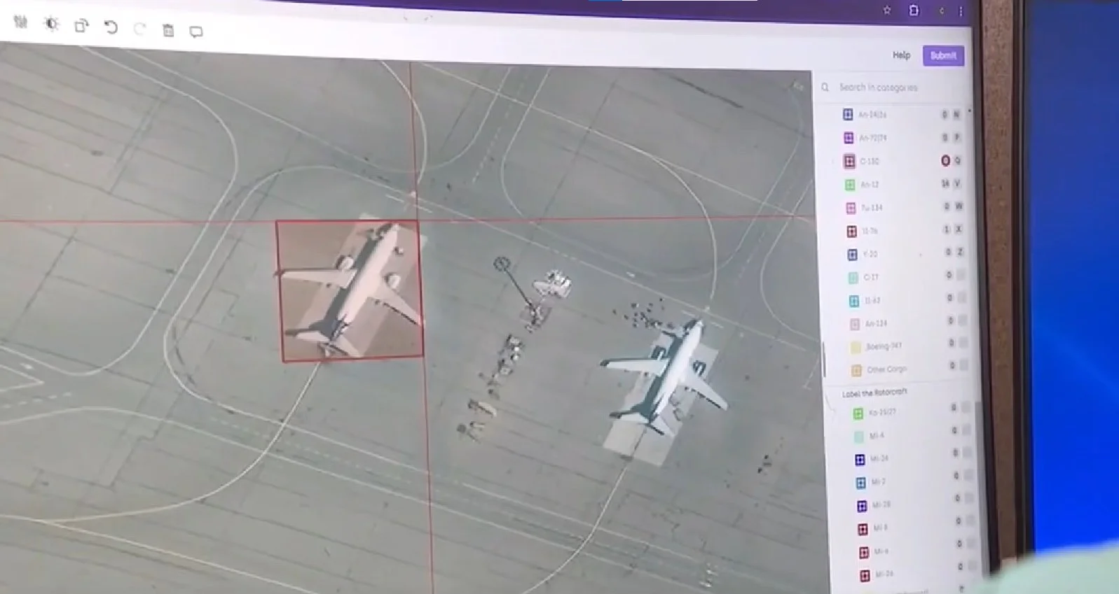
- Target recognition: Precise annotation of strategic assets, vehicles, and installations across diverse environments and imaging conditions
- Terrain classification: Detailed labeling of terrain types critical for mobility analysis, line-of-sight calculations, and operational planning
Enabled Intelligence Case Study
Enabled Intelligence, a leading provider of high-quality geospatial data for U.S. defense applications, leverages Kili Technology's platform to streamline and scale labeling workflows for complex defense-related imagery. Key achievements include:
- High-precision tactical intelligence: Utilizing geolocalized data capabilities and advanced measuring tools to achieve sub-meter annotation precision for critical defense applications
- Multi-format intelligence analysis: Successfully processing and annotating multispectral satellite imagery, synthetic aperture radar (SAR) data, and electro-optical images across diverse operational scenarios
- Human-AI collaboration: Implementing expert review workflows for mission-critical data, ensuring both efficiency and accuracy in sensitive intelligence applications
- Scalable processing: Efficiently handling thousands of high-resolution imagery assets while maintaining consistent quality standards
Environmental Conservation: Earth Observation for Ecosystem Monitoring
Environmental applications require specialized earth observation data labeling to track ecosystem health, biodiversity, and climate change impacts:
- Vegetation indices annotation: Creating training data for NDVI, EVI, and other specialized vegetation indices
- Seasonal variation handling: Maintaining consistent annotations across images captured in different seasons
- Habitat fragmentation analysis: Precisely delineating habitat boundaries and corridors using high-resolution imagery
- Coastal zone dynamics: Annotating complex shoreline changes and shallow water features
Global Ecosystems Atlas Project
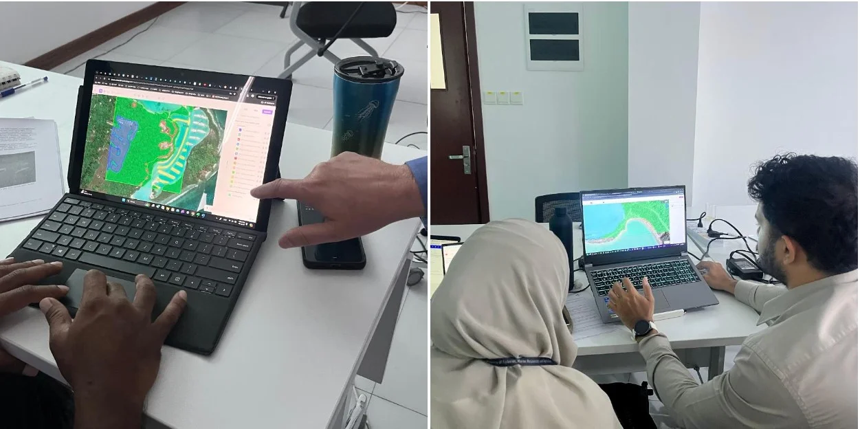
The Global Ecosystems Atlas project, supported by AI2, USGS, Planet Labs, and Esri, utilized Kili Technology's platform to develop comprehensive high-resolution maps of ecosystems in the Maldives:
- Multi-environment mapping: Precisely classifying marine environments (coral reef health, oceanic biodiversity), terrestrial landscapes (mangrove forests, island vegetation), and freshwater systems with high fidelity
- Multi-source data fusion: Integrating satellite imagery with drone footage while maintaining consistent annotation standards across different resolutions
- Standardized workflow implementation: Establishing structured annotation processes ensuring precision and consistency across complex geospatial data types
- Machine learning pipeline integration: Creating a scalable, AI-driven global mapping system with continuous improvement capabilities
Urban Planning and Infrastructure Management
Kili Technology's platform enables urban planners and infrastructure managers to:
- Building footprint extraction: Accurately delineating structures in complex urban environments with consistent labeling taxonomy
- Transportation network analysis: Detailed classification of road types, conditions, and associated infrastructure
- Land use classification: Detailed mapping of urban zones and development patterns
- Utility mapping: Precise identification of electricity poles, transmission lines, and other critical infrastructure components
Precision Agriculture Applications
Agricultural technologists leverage Kili's earth observation data labeling capabilities for:
- Crop species identification: Detailed multi-class annotation of different crop varieties within fields using multi-temporal satellite imagery
- Plant health assessment: Creating training datasets from multi-spectral imagery (particularly NIR and RedEdge bands) to detect stress indicators and disease markers
- Field boundary delineation: Precise mapping of agricultural parcels and management zones across seasons and varying crop stages
- Irrigation infrastructure mapping: Identifying and classifying irrigation equipment using high-resolution drone imagery
- Phenological stage annotation: Labeling crop growth stages across seasonal satellite imagery series
- Yield estimation training data: Creating ground-truth annotations correlating visual patterns with measured crop yields
Technical Implementation: Solving Real-World Geospatial Data Challenges
Geospatial data scientists regularly encounter memory crashes and performance bottlenecks when working with high-resolution satellite imagery spanning multiple gigabytes. Conventional annotation tools often become unusably slow or fail entirely with complex datasets. Kili Technology's geospatial annotation platform helps through:
- Intelligent memory management: Dynamically allocates resources based on annotation complexity, ensuring stable performance even with assets exceeding 1GB
- Scalability: Handles growing volumes of geospatial data without degradation in performance, allowing organizations to expand their annotation operations as needed
As annotation projects scale across multiple team members, maintaining consistent quality becomes increasingly difficult, leading to dataset inconsistencies that undermine model training. Kili Technology offers:
- Configurable validation rules that prevent common annotation errors before they propagate
- Comprehensive version control and history tracking of all annotation changes with rollback capabilities
Enterprise Integration and Security: Bridging Organizational Gaps
Organizations working with sensitive geospatial data often cannot utilize cloud-based solutions due to security protocols, especially in defense, intelligence, and certain commercial sectors where data confidentiality is paramount. Kili Technology offers:
- Complete on-premise deployment options providing full platform functionality within secure infrastructure
- Hybrid deployment models enabling secure local storage of sensitive data while leveraging cloud processing for non-sensitive workflows
- End-to-end encryption for data at rest and in transit, protecting sensitive geographic information
Geospatial data often contains information subject to regulatory restrictions such as GDPR, CCPA, or FedRAMP, creating compliance challenges that generic annotation tools fail to address:
- Detailed audit logging for compliance verification and security monitoring
- Role-based access control with granular permission settings limiting data exposure
- Configurable data retention policies aligning with regulatory requirements
In large organizations, geospatial data workflows typically involve multiple teams using different software platforms and data formats, creating disjointed processes and information silos:
- Robust API and Python SDK enabling programmatic access to core functionalities
- Direct integration with major cloud storage platforms (AWS S3, Google Cloud Storage, Microsoft Azure)
- Seamless compatibility with different coordinate reference systems and GIS software
By addressing these technical and organizational challenges, Kili Technology enables geospatial data scientists to focus on extracting insights rather than struggling with tool limitations or security concerns. This problem-solving approach transforms geospatial annotation from a technical bottleneck into a streamlined process that accelerates the development of earth observation AI applications.
Conclusion: Choosing the Right Tool for Geospatial Data Annotation
Open-source geospatial annotation tools like QGIS provide valuable options for individual users, academic projects, and small teams with basic annotation requirements. While tools like CVAT offer collaborative capabilities, they lack native support for geospatial data formats and coordinate systems. For organizations dealing with complex, large-scale earth observation data from satellites, aircraft, and drones, these tools often reach their limits in terms of performance, specialized functionality, and quality control.
Kili Technology's geospatial annotation platform offers a comprehensive solution that addresses these limitations while providing specialized features for professional earth observation data scientists. By combining advanced satellite and aerial imagery annotation capabilities, AI-assisted labeling, and enterprise-grade quality control, Kili enables organizations to create high-quality, standardized geospatial datasets that power the next generation of machine learning applications. For geospatial professionals looking to scale their remote sensing data annotation workflows without sacrificing precision or efficiency, enterprise solutions like Kili Technology represent the optimal balance of specialized functionality and performance.
The platform's demonstrated success across defense intelligence, environmental conservation, urban planning, and precision agriculture applications underscores its versatility and effectiveness for demanding earth observation projects requiring the highest standards of annotation accuracy and consistency.
![Best On-Premise Data Labeling Platforms for Regulated Industries [2026] Guide](https://cdn.prod.website-files.com/68da32b2041c593b0511a582/6a574849a90d08dc8b9b547d_Competitor%20Article%20-%20Listicle%201%20(2).webp)