Satellite imagery annotation is the process of labeling or marking specific features within satellite images. This process is crucial for converting raw satellite imagery into actionable, structured data that can be used for various analytical purposes and building computer vision models. Some use cases for using satellite imagery are the following:
- Crop Monitoring: Geospatial data annotations can help identify different crop types and assess their health or growth stages. This information is used for precision agriculture, optimizing irrigation, and predicting yields.
- Deforestation Tracking: Satellite imagery can be annotated to monitor changes in forest cover, helping to track illegal deforestation or forest degradation.
- Property Analysis: Satellite annotations can help assess property values by analyzing the surrounding infrastructure, green spaces, and other environmental factors.
- Damage Assessment: After natural disasters, geospatial image annotation can quickly provide insights into the extent of damage, helping to prioritize response efforts.
In all these cases, high-quality datasets are important for deeper insights and high-performing models. This type of data annotation faces several challenges, primarily due to the data's unique nature and the tasks' complexity:
- Large Images and High Volume of Data: Satellite imagery generates vast amounts of data daily. Processing and annotating this data requires significant computational resources and efficient algorithms to manage and analyze the imagery efficiently.
- Complex and Diverse Features: The Earth's surface is incredibly diverse, with complex features that can be difficult to annotate accurately. Differentiating between similar-looking features (e.g., distinguishing between vegetation types or natural and man-made structures) requires sophisticated tools, algorithms, and often manual verification.
- Geospatial Accuracy: Ensuring that annotations are correctly geolocated is crucial, especially for applications requiring precise location data, such as urban planning or disaster response. Errors in geolocation can lead to significant inaccuracies in the data.
An effective annotation tool for satellite imagery and geospatial data analysis needs to offer advanced functionalities tailored to the unique requirements of geospatial data, support efficient and scalable annotation processes, and integrate seamlessly with machine learning workflows.
This is where the power of a specialized labeling interface like Kili comes into play. In the following, we will highlight the key challenges encountered in the satellite imagery sector. We’ll focus on three key solutions in the article:
- Tackling large satellite image annotation
- Accurate geospatial data annotation with GeoTIFF images
- Enhanced Analysis with Multi-spectral Images
Tackling large satellite image annotation
Geospatial images are often large in resolution and data volume, presenting significant computational challenges.
- Performance Issues with Large Images: Handling and processing large images, particularly those over 30MB, can be computationally expensive and slow. This is because loading, displaying, and interacting with high-resolution images demands significant memory and processing power, which can lead to performance bottlenecks in image annotation tools.
- Difficulty in Annotation: When annotating large images for machine learning or data analysis purposes, it's crucial to zoom in and out and navigate the image smoothly to annotate objects accurately. Performance limitations can make this process cumbersome, leading to inefficiency and potentially lower-quality annotations.
- High Scalability on Geospatial Images:
- Lazy loading is enabled for geospatial images containing more than 1,000 annotations. This feature allows only the annotations visible within the viewport to be loaded, resulting in a more seamless navigation experience. This enhancement is especially beneficial when dealing with dense, complex annotations, like intricate semantic segmentation masks.
Kili's platform goes beyond the typical image annotation tool by addressing the challenge of handling large images with a feature called 'image tiling'. This process automatically divides images larger than 30MB into smaller, manageable tiles. Here's how it works:
- Dividing Images into Manageable Tiles: By automatically dividing large images into smaller, manageable tiles, Kili's platform ensures that only the parts of the image currently being viewed or annotated need to be loaded into memory. This significantly reduces the computational resources and loading times.
- Improved Navigation and Zooming: With image tiling, users can smoothly navigate and zoom into specific areas of the image without experiencing the slowdowns that typically occur with large file sizes. This allows for more precise annotations, as the annotator can easily focus on detailed areas without waiting for the entire image to load or refresh.
Overall, this feature enhances the user experience by making the annotation process more efficient and less frustrating. Annotators can work more effectively and create bounding boxes or polygon annotation, leading to quicker project completion times and potentially higher-quality data for machine learning models.
The Power of SAM2: A Foundation Model for Visual Segmentation
SAM2 represents a significant evolution in visual segmentation technology, offering groundbreaking improvements in accuracy and efficiency. Developed by Meta’s research team, this advanced foundation model employs a sophisticated transformer architecture, optimized for real-time image segmentation.
With SAM2, annotators experience transformative capabilities:
- Reduced User Interactions: Up to three times fewer interactions are required compared to previous approaches, enabling faster workflows without compromising quality.
- Enhanced Precision: SAM2 consistently delivers superior accuracy across a wide range of segmentation tasks, making it a reliable tool for professionals.
- Optimized Performance: The model’s ability to maintain consistent results in challenging scenarios ensures it’s well-suited for geospatial applications.
By integrating SAM2, Kili Technology provides annotation teams with a powerful ally in tackling the complexities of satellite imagery.
Powerful Flexibility with Dual Model Approach
To meet the diverse needs of annotation teams, our implementation of SAM2 includes two specialized models:
- Rapid Model: Ideal for projects where speed is crucial, this model delivers quick results without sacrificing essential accuracy. It’s perfect for teams managing large-scale datasets or working under tight deadlines.
- High-res Model: When precision is paramount, the High-res Model offers unmatched accuracy, ensuring every detail is captured correctly. This model is particularly useful for tasks requiring meticulous attention to fine-grained features.
With this dual-model approach, annotators can choose the best tool for their specific project requirements, enhancing both efficiency and quality.
Tackle the challenges of satellite imagery annotation with Kili Technology
High-quality datasets are crucial for deeper insights and high-performing models. Harness the full potential of satellite imagery with our geospatial annotation tool.
Geospatial data annotation with GeoTIFF images
Data scientists requiring GPS coordinates in annotating images need a tool adept at handling GeoTIFF files. Traditional image annotation software may not support the direct use of geospatial metadata embedded within images, making it challenging for users to work with GeoTIFF files effectively. This can hinder the annotation process for projects requiring precise geographic information.
For those dealing with real world coordinates, Kili is adept at handling GeoTIFF files, which come with embedded geospatial metadata. Kili makes this complex geospatial labeling as straightforward as labeling standard images.
Pinpoint Accuracy with GPS Coordinates and Measurement Tools
Obtaining precise GPS coordinates from an image for annotation or analysis is often cumbersome and prone to error, especially when manual methods are used. This precision is crucial for applications like mapping, environmental monitoring, and urban planning. Kili simplifies the process of obtaining precise geographic data. With a simple right-click or a keyboard shortcut, you can copy the GPS coordinates of any point on the image.
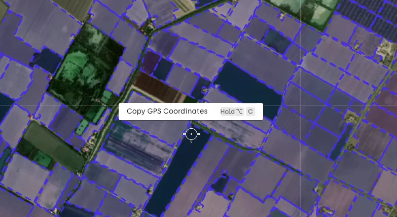
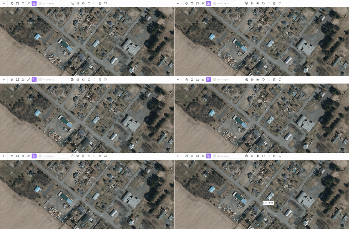
Measuring distances directly on geospatial images is typically challenging without specialized tools, making it difficult to accurately assess the size of objects or distances between points. This information can be critical for classifications, environmental studies, and infrastructure planning. Kili lets you measure distances between points directly on the image, providing measurements in meters and feet. This feature is particularly useful when the size of an object is crucial for classification.
Retention of Geospatial Context in Exported Data
When exporting annotated data, maintaining the geospatial context of the annotations is essential for further analysis or integration into GIS (Geographic Information Systems). Many tools strip out this valuable metadata, diminishing the utility of the exported data. Kili ensures that when you export your annotations, they include the corresponding geo coordinates sourced from the image's metadata, keeping longitude as 'x' and latitude as 'y'. This feature preserves the spatial context of the data, which is crucial for applications requiring geolocation accuracy, such as environmental monitoring, land use planning, and disaster management.
Enhanced Analysis with Multi-spectral Images

Multi-spectral imaging allows for the analysis of invisible characteristics and conditions in standard images. For instance, in agriculture, different bands can indicate plant health, moisture content, or pest stress before such conditions are visible to the human eye, enabling early intervention. The use of multi-spectral images can also help improve object detection and classification.
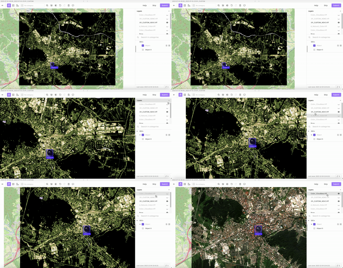
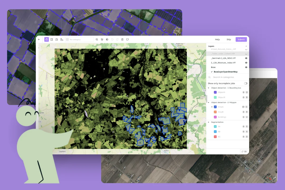
For those delving into multi-spectral GeoTIFF images, Kili offers the possibility to rely on various layers to ease the labeling task.
- Handling Multi-Spectral Data Complexity: Multi-spectral GeoTIFF images contain data across various spectral bands, each providing different information about the same location. Working with these layers individually can be complex and time-consuming, especially when trying to correlate insights across the spectra. Kili simplifies the process by enabling users to toggle between different spectral layers, facilitating easier comparison and analysis without needing separate tools or manual alignment efforts.
- Enhancing Precision in Annotations: By allowing users to view and annotate the image through various spectral lenses, Kili enhances the precision of annotations, as annotators can select the most informative spectral band for identifying and labeling specific features.
Solving the challenges of geospatial data annotations with ease
The challenges of satellite imagery annotation are significant but not insurmountable. With the right tools and approaches, such as those offered by Kili, organizations can effectively tackle the complexities of large image handling, precise geospatial data annotation, and enhanced analysis through multi-spectral images. These capabilities are crucial for harnessing the full potential of satellite imagery across various applications, from agriculture and environmental monitoring to urban planning and disaster management.
As we've seen, combining advanced features like image tiling, support for GeoTIFF images, and the ability to work with multi-spectral data can significantly improve the efficiency and quality of satellite imagery annotation projects. By addressing the key challenges head-on, Kili empowers data scientists, GIS professionals, and organizations to transform vast amounts of raw satellite data into actionable insights and high-performing machine-learning models.
Explore how Kili's specialized labeling interface can revolutionize your approach to satellite imagery annotation. Contact us today to learn more or schedule a demo.

.png)
_logo%201.svg)


