.png)


_logo%201.svg)


AI Summary
We've been supporting geospatial annotation through our image projects for some time now, providing core capabilities like geo-referencing, layer management, and tiled support for large imagery. While this foundation has served our users well, we've been listening to feedback from the geospatial community about their evolving needs.
Today, we're announcing Geospatial Projects – a new project type built specifically for geospatial workflows. While our existing image projects have provided solid geospatial annotation features like geo-referencing and layer management, this new project type addresses the specialized requirements we've heard from our geospatial community.
Why Geospatial Projects?
For some time, our platform has supported geospatial data through image projects, offering essential features like geo-referencing and layer management. However, as we've worked with more geospatial data experts – from defense applications detecting vessels on SAR imagery to agricultural monitoring in challenging environments – we've learned that building geospatial datasets has unique requirements that deserve dedicated tools.
From multispectral image analysis to collaborative analysis workflows, geospatial datasets involve specific data types, visualization needs, and integration requirements that are distinct from standard image annotation.
That's why we've developed Geospatial Projects: a solution designed with geospatial standards and workflows in mind, built to better support the specific needs of building geospatial datasets.
What's New for Geospatial Users
The development of Geospatial Projects addresses several key areas where we've seen the greatest need for improvement:
Enhanced File Handling and Performance
Cloud Optimized GeoTIFF (COG) Support
We've rebuilt our file processing architecture with COG files in mind, resulting in several immediate benefits:
- Faster imports: Tiles are no longer pre-generated during import, significantly reducing upload time,
- Dynamic tiling: Tiles are generated and rendered on the fly in the user interface, based on the selected Geospatial settings,
- Larger file support: Upload significantly larger files—up to 5 GB per asset—compared to the 1 GB limit in standard image projects
Improved Multispectral Data Processing
The updated COG support now also means that multispectral data can be handled more easily with the following features:
- Full band preservation: All image bands are preserved during import—not just the first three (RGB). Users can map any band combination to RGB through the Geospatial Settings in the interface.
- Built-in index calculations: Easily create and visualize vegetation or thermal indices like NDVI directly in the interface, using formulas. Apply color maps to enhance interpretation and facilitate analysis during annotation.
- 16-bit image optimization: Adjust minimum and maximum display values to improve visualization of high bit-depth imagery, such as SAR images, for more accurate interpretation.
Better Visualization and Streamlined Navigation
Large geospatial datasets present unique navigation challenges. We've addressed this with two key features:
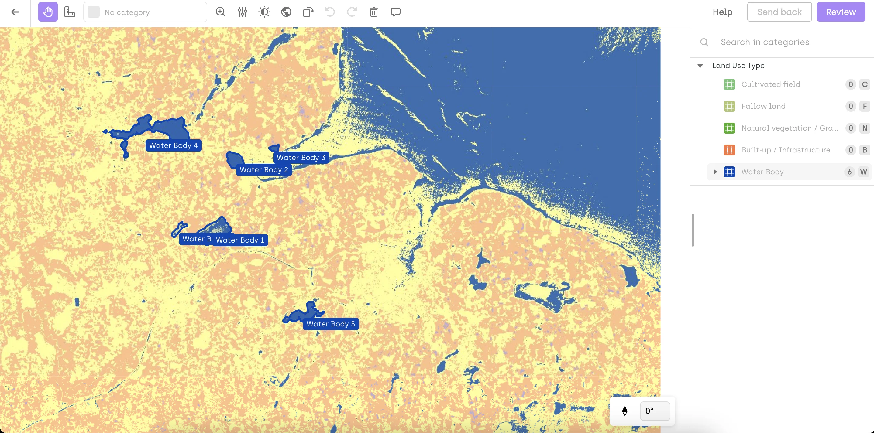
Mini-map integration: A built-in mini-map shows the full image extent and highlights the current viewport, helping users instantly understand which part of the image they are working on.
Zoom-to-fit: Easily locate and focus on a labeled object by clicking the focus icon. The view automatically adjusts to center and zoom in on the selected object, streamlining navigation and annotation.
Seamless GIS Integration
Direct Shapefile import: You can now directly import annotations from .shp files into Kili without the need for any additional conversion steps.
This feature eliminates a common friction point in geospatial workflows, allowing teams to move seamlessly between their existing GIS tools and Kili's annotation environment.
What's Next
This beta release establishes the foundation for Geospatial Projects. Over the coming weeks and months, we'll continue expanding functionality, deepening GIS integration, and refining the user experience based on feedback from our community.
Our commitment is to deliver a platform that combines powerful GIS capabilities with the collaborative, scalable workflows needed to build high-quality geospatial datasets.
While we'll continue supporting geospatial data in our existing Image Projects, future improvements specifically tailored to geospatial workflows will be developed exclusively within Geospatial Projects.
Join the Beta
Geospatial Projects are currently available in beta upon request. We'd love to discuss how these enhanced capabilities could support your specific geospatial workflows. Our team is ready to explore how Geospatial Projects can add value to your organization's data annotation needs. Get exclusive access and a direct line with our product team for feedback and feature requests. Start a consultation with our team here.
![Best On-Premise Data Labeling Platforms for Regulated Industries [2026] Guide](https://cdn.prod.website-files.com/68da32b2041c593b0511a582/6a574849a90d08dc8b9b547d_Competitor%20Article%20-%20Listicle%201%20(2).webp)