Aerial imagery and Satellite Imagery: what's the difference?
Aerial Imagery
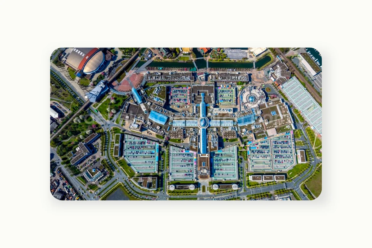
Aerial images are invaluable visual resources comprising photographs or digital images captured from various airborne platforms, such as airplanes, helicopters, drones, and even balloons. These platforms enable data collection at lower altitudes, resulting in images that offer a remarkable level of detail and high-resolution views of the targeted areas.
Aerial imagery serves as a powerful tool across numerous domains, including urban planning, environmental monitoring, disaster management, and infrastructure assessment. By leveraging the unique vantage point provided by aerial platforms, organizations and researchers can obtain precise and comprehensive visual insights into landscapes, buildings, terrain, and other features of interest.
Furthermore, aerial images allow for precise mapping, analysis, and documentation of areas that may be otherwise challenging to access or survey, making them an indispensable resource for informed decision-making and impactful research.
Aerial images possess key characteristics that make them invaluable for a wide range of applications:
- Image Acquisition: Aerial images are meticulously captured using specialized cameras mounted on aircraft or other airborne platforms. This controlled acquisition process allows for targeted imaging of specific areas or features of interest. Whether for mapping, surveillance, or environmental monitoring, aerial imagery offers precise and intentional data collection.
- Spatial Resolution: A notable advantage of aerial images is their high spatial resolution, thanks to the close proximity of the imaging platform to the Earth's surface. This enables the capture of intricate details, facilitating the accurate identification and analysis of objects or features within the images. The enhanced spatial resolution empowers professionals across diverse fields, including urban planning, agriculture, and infrastructure assessment, to extract meaningful insights from the imagery.
- Temporal Resolution: Aerial images can be obtained at varying time intervals, depending on the specific purpose and requirements of a project. This flexibility allows for frequent image acquisition, providing up-to-date and time-sensitive information for monitoring, change detection, and trend analysis. By capturing aerial imagery as frequently as necessary, organizations can stay informed about evolving landscapes, track dynamic processes, and make informed decisions based on the most recent data.
Embracing the key characteristics of aerial images, professionals can unlock their full potential in applications ranging from land management and disaster response to environmental conservation and beyond. The rich spatial and temporal resolutions of aerial imagery empower decision-makers, researchers, and analysts to delve deeper into understanding our world from above.
Satellite Imagery
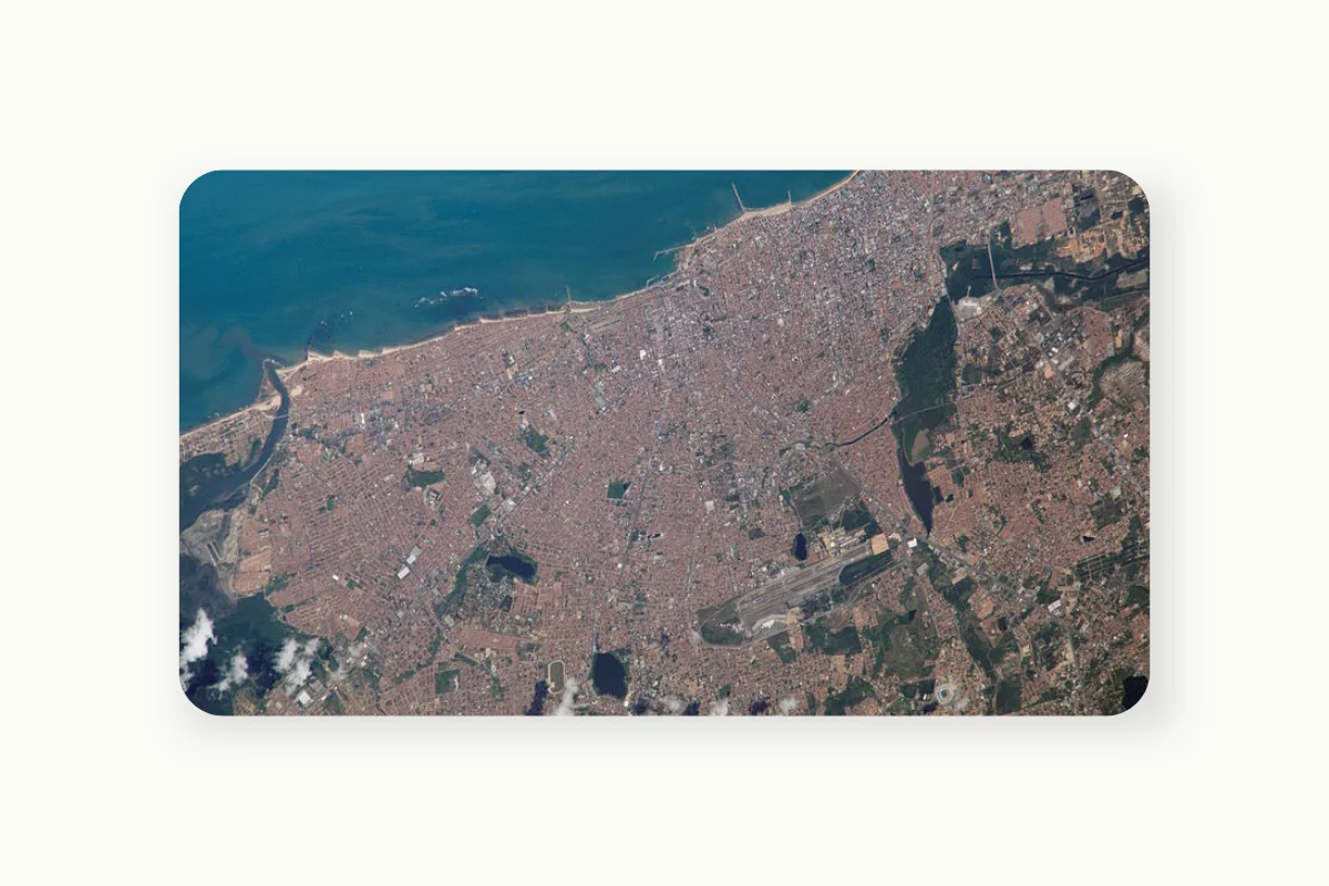
Satellite images, captured by orbiting satellites owned by various entities such as government agencies, private companies, and international organizations, provide a comprehensive and expansive view of the Earth's surface, covering vast areas that would otherwise be challenging to monitor. These high-resolution images offer valuable insights and data for a wide range of applications across various fields.
One significant application of satellite imagery is in land use planning. By analyzing satellite images, urban planners and policymakers can gain a holistic understanding of the existing land cover and land use patterns. This information aids in making informed decisions about urban development, infrastructure planning, and sustainable resource management. Satellite images also play a vital role in monitoring and assessing changes in natural habitats, identifying deforestation, and preserving ecological balance.
Environmental monitoring is another critical area where satellite imagery proves invaluable. With their high-altitude perspective and regular imaging intervals, satellites enable continuous observation of the Earth's surface, capturing data on a global scale. This long-term monitoring allows scientists and researchers to track and analyze changes in vegetation health, land degradation, coastal erosion, and climate patterns. Satellite imagery also facilitates the identification of vulnerable areas prone to natural disasters such as floods, wildfires, and hurricanes, aiding in disaster preparedness, response, and mitigation efforts.
Satellite images possess key characteristics that make them indispensable for a wide range of applications:
- Image Acquisition: Satellite images are acquired through sensors onboard satellites orbiting the Earth. These satellites meticulously follow predefined paths and capture images as they traverse specific regions. The timing and coverage of satellite image acquisition are predominantly determined by the satellite's orbital path and revisit time, allowing for systematic and controlled data collection.
- Spatial Resolution: Satellite images exhibit varying levels of spatial resolution, contingent upon the satellite and sensor utilized. Generally, satellite imagery offers coarser resolutions compared to aerial images, primarily due to the greater distance between the satellite and the Earth's surface. Nevertheless, advancements in satellite technology have led to significant improvements in spatial resolution for certain satellites, enabling finer details to be discerned and enhancing their applicability for tasks such as land cover classification and urban planning.
- Temporal Resolution: An invaluable feature of satellite imagery is its global coverage and the ability to capture images at regular intervals. The temporal resolution varies across different satellite systems, with some satellites capable of capturing imagery on a daily basis, while others may have longer revisit times. This temporal perspective facilitates the monitoring of dynamic processes, such as vegetation growth, land use changes, and natural disasters, enabling timely analyses and informed decision-making.
By harnessing the distinctive characteristics of satellite images, organizations and researchers gain access to a wealth of information for environmental monitoring, disaster response, climate studies, and more. The controlled acquisition, varying spatial resolutions, and temporal coverage make satellite imagery a vital tool in understanding our planet and addressing critical challenges.
Aerial imagery and Satellite Imagery: What should I go for?
When considering the acquisition of data for specific needs, several factors come into play, including temporal requirements, spatial resolution, and cost considerations. For applications requiring large-scale and continuous data collection over time, satellite imagery proves advantageous.
Despite lower spatial resolution, satellite data offers comprehensive temporal coverage, making it suitable for tasks such as long-term environmental monitoring and global trend analysis. Alternatively, when precise data capture at a specific point in time and high spatial resolution are paramount, aerial imagery emerges as the preferred choice.
Aerial imagery, obtained through platforms like aircraft or drones, provides finer details and enhances spatial resolution, enabling accurate feature identification and analysis for applications such as infrastructure inspection and urban planning.
Cost is an additional factor to consider. Satellite data, particularly open-source datasets, are readily accessible, enabling quick and efficient utilization. Moreover, private vendors offer commercially available satellite images, often with enhanced spatial resolutions and pre-processed data, catering to specific requirements and demanding applications.
By carefully evaluating the temporal needs, spatial resolution, and cost considerations, researchers and professionals can make informed decisions regarding the selection of either satellite or aerial imagery, ensuring optimal data acquisition for their specific objectives.
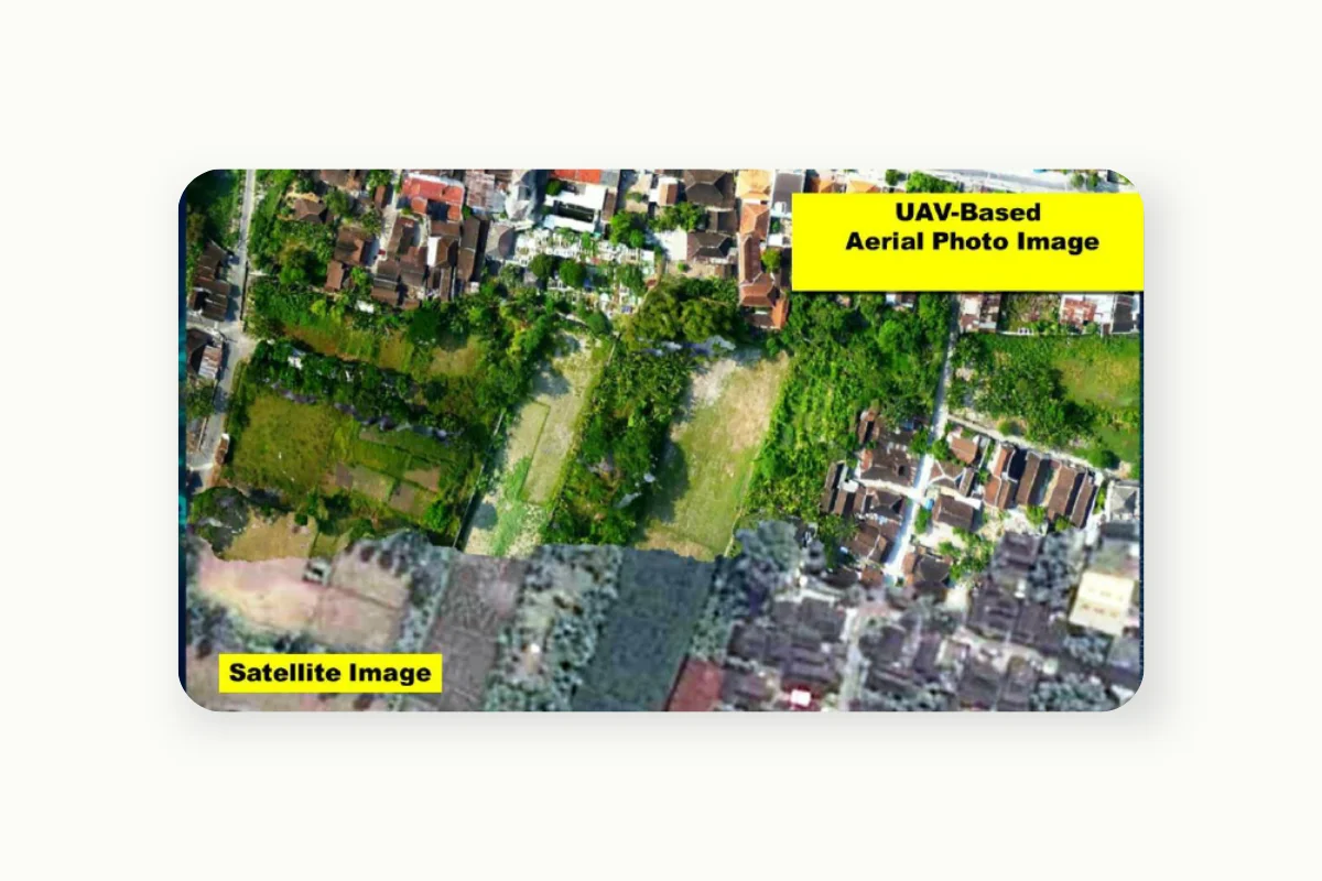
Aerial and Satellite Imagery: Their Impact on Your ML Pipeline
Overall, the biggest differences you’ll notice between Satellite Imagery and Aerial Imagery will happen at the data collection, preprocessing, and feature extraction stages.
Training Data Collection
Aerial and satellite images hold immense value as data sources for training machine learning (ML) models, contributing to various applications. However, the process of annotating these images presents unique challenges that need to be addressed.
One of the primary obstacles lies in their inherent characteristics, such as their typically large size and the abundance of objects within them that require annotation. Furthermore, the spatial resolution of these images often tends to be low, which can complicate the accurate identification and understanding of objects present within the imagery.
Overcoming these challenges requires efficient annotation strategies and advanced techniques like Kili's labeling platform to ensure the effective utilization of aerial and satellite images in ML model training, ultimately unlocking their full potential in diverse domains and applications
Data Preprocessing and Preparation
Aerial and satellite images often necessitate preprocessing and careful preparation before integrating them into machine learning (ML) pipelines. This crucial step involves a series of tasks aimed at optimizing the image data for effective analysis by ML algorithms.
Preprocessing encompasses various techniques, such as image enhancement methods like contrast adjustment and noise reduction, which enhance the visual quality and clarity of the images.
Additionally, georeferencing techniques are employed to assign accurate spatial coordinates to the images, enabling their alignment with geographic information systems (GIS) data. Moreover, calibration procedures are performed to rectify any distortions present in the imagery, ensuring the images are in a suitable format and quality for ML algorithms to learn from efficiently.
By undertaking these preprocessing steps, aerial and satellite images are better prepared to serve as valuable inputs for ML models, leading to more accurate and reliable outcomes.
Feature Extraction and Representation
Aerial and satellite images offer a wealth of rich visual features that hold immense potential as inputs for machine learning (ML) models. These images encompass a range of informative attributes, including texture, color, shape, and spatial information. ML pipelines leverage sophisticated algorithms to extract and represent these features, enabling models to learn intricate patterns and make accurate predictions based on the extracted information from the images.
It is important to note that satellite imagery possesses its own unique set of features. In the case of multi-band images, compelling indices can be derived by combining various color bands to provide valuable insights into ground characteristics. Notably, the vegetation index stands as a renowned example, providing information on the presence and density of vegetation across the landscape.
By formulating specific indices, satellite imagery enables ML models to acquire deeper understanding and deliver more nuanced analyses for applications such as environmental monitoring, agriculture, and land cover classification.
By leveraging the rich visual features inherent in aerial and satellite images and employing advanced feature extraction techniques, ML models can harness the immense potential of these datasets, leading to more accurate and insightful predictions across diverse domains.
Use Cases
Aerial Images
Urban Planning: Leveraging Aerial Images for Building Detection
Aerial images play a crucial role in urban planning applications, specifically in building detection and analysis. By harnessing the power of machine learning algorithms, it becomes possible to automatically identify and classify buildings within a given area using aerial imagery. This valuable information contributes to urban development, infrastructure planning, and population density analysis.
Machine learning models trained on aerial images exhibit remarkable accuracy in detecting buildings, estimating their sizes and locations, and providing actionable insights for urban planners and city administrators.
Example Use Case: Assessing Urban Expansion and Identifying Potential Residential Development Areas
Let's consider a practical scenario where a city government aims to evaluate urban expansion and identify suitable locations for new residential development. By employing machine learning algorithms trained on aerial images, the government can seamlessly detect and map existing buildings throughout the city.
Analyzing the distribution and density of these buildings enables them to pinpoint areas with potential for future construction, optimize urban planning strategies, and make well-informed decisions regarding land use and zoning regulations. This application highlights how aerial imagery, coupled with advanced machine learning techniques, empowers urban planners to drive sustainable and efficient development initiatives.
Satellite Images
Satellite images offer invaluable insights for crop and vegetation monitoring in agriculture. By harnessing the capabilities of machine learning models trained on satellite imagery, it becomes possible to assess crop health, predict yields, detect anomalies, and optimize farming practices. Leveraging the spectral information captured by satellites, agricultural professionals can monitor plant health, identify areas affected by pests or diseases, and implement timely interventions for improved crop management.
Example Use Case: Large-Scale Crop Health Monitoring and Optimization
Let's consider a practical example where a large-scale agricultural company seeks to monitor the health and productivity of their crops across extensive farmland areas. By utilizing satellite images and leveraging vegetation indices such as the Normalized Difference Vegetation Index (NDVI), which indicates vegetation presence and density, they can train a machine learning algorithm. This algorithm, based on the NDVI and trained on satellite images over time, empowers them to identify areas experiencing potential crop stress.
Armed with this information, they can optimize irrigation strategies, schedule targeted interventions, and maximize overall crop yield. This application demonstrates the immense potential of satellite imagery and machine learning in revolutionizing agricultural practices for enhanced productivity and sustainability.
FAQ
Can I find a free image labeling tool for creating custom training datasets from satellite imagery?
There are several free image labeling tools available for creating custom training datasets from satellite imagery. One of the best tools is Kili Technology's labeling platform which offers a free plan that allows you to annotate and label satellite imagery for training datasets.
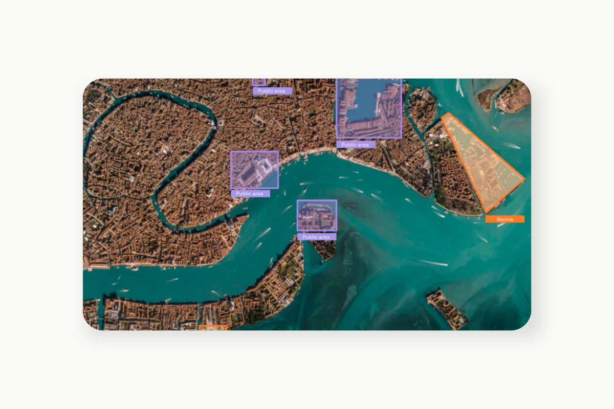
What are Convolutional Neural Networks (CNNs)?
Convolutional Neural Networks (CNNs) are a type of deep learning algorithm specifically designed for processing and analyzing visual data, such as images and videos. They have revolutionized the field of computer vision by achieving remarkable performance in various tasks, including image classification, object detection, and image segmentation.
CNNs are inspired by visual processing mechanisms in the human brain. They consist of multiple layers, each responsible for different operations.
How object detection could be used in aerial imagery?
Object detection in aerial imagery has a wide range of applications across various domains. In urban planning and infrastructure, it can be utilized to identify and analyze buildings, roads, bridges, and other infrastructure elements in aerial images, providing valuable insights for city development and future planning.
In agriculture, object detection helps monitor and track crops, assess vegetation health, and detect diseases, enabling precision agriculture practices for optimized resource allocation and increased yield predictions. For environmental monitoring, object detection aids in identifying and monitoring features such as forests, water bodies, wetlands, and land cover types, facilitating ecosystem assessment and conservation efforts. Overall, object detection in aerial imagery plays a vital role in diverse fields by providing valuable information and insights for decision-making and resource management.
What is semantic segmentation labeling?
Semantic segmentation labeling is a process in computer vision and image analysis that involves labeling each pixel in an image with a corresponding class label. Unlike object detection, which identifies and localizes individual objects within an image, semantic segmentation assigns a label to every pixel, creating a dense prediction map that highlights different regions or objects of interest.
The goal of semantic segmentation is to partition an image into meaningful and coherent regions based on the semantic understanding of the scene. Each pixel is assigned a label representing the category or class it belongs to, such as person, car, road, tree, etc. This fine-grained labeling enables detailed analysis of the image, allowing for pixel-level understanding and accurate delineation of objects or regions.
Semantic segmentation labeling is essential in various applications, including autonomous driving, medical image analysis, scene understanding, and video surveillance. It aids in tasks like object recognition, scene understanding, instance segmentation, and visual understanding for artificial intelligence systems. By providing a detailed understanding of the image at the pixel level, semantic segmentation plays a crucial role in advancing computer vision applications.
Watch video

.png)

_logo%201.svg)


