.png)

_logo%201.svg)


AI Summary
Geospatial data has become a cornerstone for industries ranging from defense to environmental conservation. However, the challenges of working with high-resolution satellite imagery, vast datasets, and complex geospatial features require sophisticated annotation tools. Kili Technology’s geospatial annotation platform is built to meet these challenges, offering cutting-edge features that streamline labeling while ensuring precision and scalability.
In this article, we’ll dive into the spectrum of Kili Technology’s geospatial annotation tool and highlight how its features has been able to progress vital use cases in both Defense and Climate Protection organizations.
Advanced Tooling for Geospatial Annotation
Kili Technology’s geospatial annotation tool is specifically designed to handle high-resolution geospatial imagery and large file sizes. The platform supports various annotation types, including:
- Bounding Boxes: Useful for object detection and classification in aerial and satellite imagery.
- Polygons: Enables precise delineation of complex geographical features, such as land use areas and infrastructure.
- Semantic Segmentation: Facilitates pixel-level classification, crucial for identifying terrain types and ecosystem components.
Key Features
- Optimized Handling of High-Resolution and Large File Sizes – Geospatial images are often massive, sometimes hundreds of megabytes in size, requiring smooth loading, navigation, and zooming capabilities to ensure annotators can work efficiently without performance bottlenecks.
- Geo-Referenced Annotations with Precise Metadata – Unlike standard images, each pixel in geospatial imagery corresponds to real-world coordinates. The platform maintains geo-coordinates metadata, ensuring annotations are spatially accurate and aligned with real-world locations.
- Multispectral and Multi-Format Support – The platform supports beyond-RGB imagery, including infrared, thermal, and hyperspectral data, enabling advanced analysis for applications such as vegetation health assessment, water body detection, and land use planning.
- Seamless Integration with Different Projections – Geospatial data comes in various coordinate reference systems (CRS), often defined by EPSG codes. The annotation platform is designed to handle diverse projection systems, ensuring compatibility with different GIS workflows and remote sensing applications.
Case Study: Enabling High-Quality Geospatial Data for Defense
Enabled Intelligence, a leading provider of high-quality geospatial data for U.S. defense applications, leverages Kili Technology’s geospatial annotation tool to streamline and scale its labeling workflows. Given the complexity of defense-related geospatial imagery, the company required a solution capable of handling diverse datasets with unparalleled accuracy.
By implementing Kili’s advanced geospatial annotation platform, Enabled Intelligence achieved:
✅ High-Quality, Precision Labeling – Kili Technology’s suite of features for geospatial labeling improved annotation accuracy across multiple data types, ensuring high-fidelity labels for defense intelligence. Enabled Intelligence employed geolocalized data capabilities and an advanced measuring tool to achieve highly precise annotations, essential for tactical and operational intelligence applications.
✅ Scalability for Large Geospatial Datasets – Kili’s platform seamlessly handled massive satellite and aerial imagery files, allowing Enabled Intelligence to annotate thousands of labels efficiently.
✅ Versatility Across Data Types – The ability to label hyperspectral satellite imagery, SAR images, and electro-optical images enabled defense applications to cover a broad range of use cases, from material identification to reconnaissance in low-visibility conditions.
✅ Human-in-the-Loop Verification for Mission-Critical Accuracy—Enabled Intelligence integrated expert review mechanisms into the annotation pipeline, ensuring AI-generated labels were refined through human oversight. This process improved the reliability of classified geospatial data, reduced errors in intelligence assessments, and strengthened decision-making for defense operations.
With Kili Technology’s support, Enabled Intelligence has successfully elevated the quality and scale of labeled geospatial data for defense applications, ensuring mission-critical intelligence is derived from highly precise and well-annotated imagery.
Case Study: High-Precision Mapping of the World’s Ecosystems
The Global Ecosystems Atlas, supported by AI2, USGS, Planet Labs, and Esri, is a groundbreaking initiative focused on developing the first comprehensive, high-resolution map of ecosystems in the Maldives. To achieve this ambitious goal, the project relies on Kili Technology’s AI-powered geospatial annotation platform, which ensures high-quality, standardized mapping of marine, terrestrial, and freshwater environments.
Mapping the Maldives’ Diverse Ecosystems
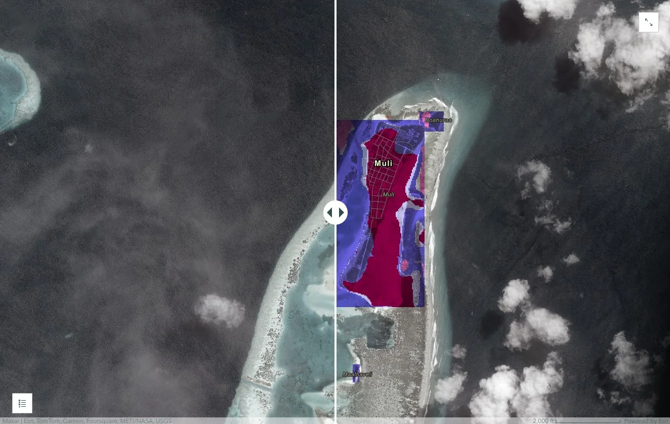
An example of the results of the Global Ecosystems Atlas project in Maldives.
Through Kili Technology’s advanced geospatial annotation tools, the project enables precise classification of:
✅ Marine Environments – Mapping coral reef health, oceanic biodiversity, and coastal erosion with high fidelity.
✅ Terrestrial Landscapes – Identifying and monitoring mangrove forests, island vegetation, and urban expansion.
✅ Freshwater Systems – Classifying wetlands, lagoons, and coastal freshwater ecosystems to support conservation strategies.
Kili Technology: A Key Driver for High-Accuracy Mapping
Kili’s AI-assisted annotation platform was instrumental in ensuring the accuracy, quality, and scalability of ecosystem mapping efforts. By integrating multi-source data fusion and a robust quality control framework, the project achieved:
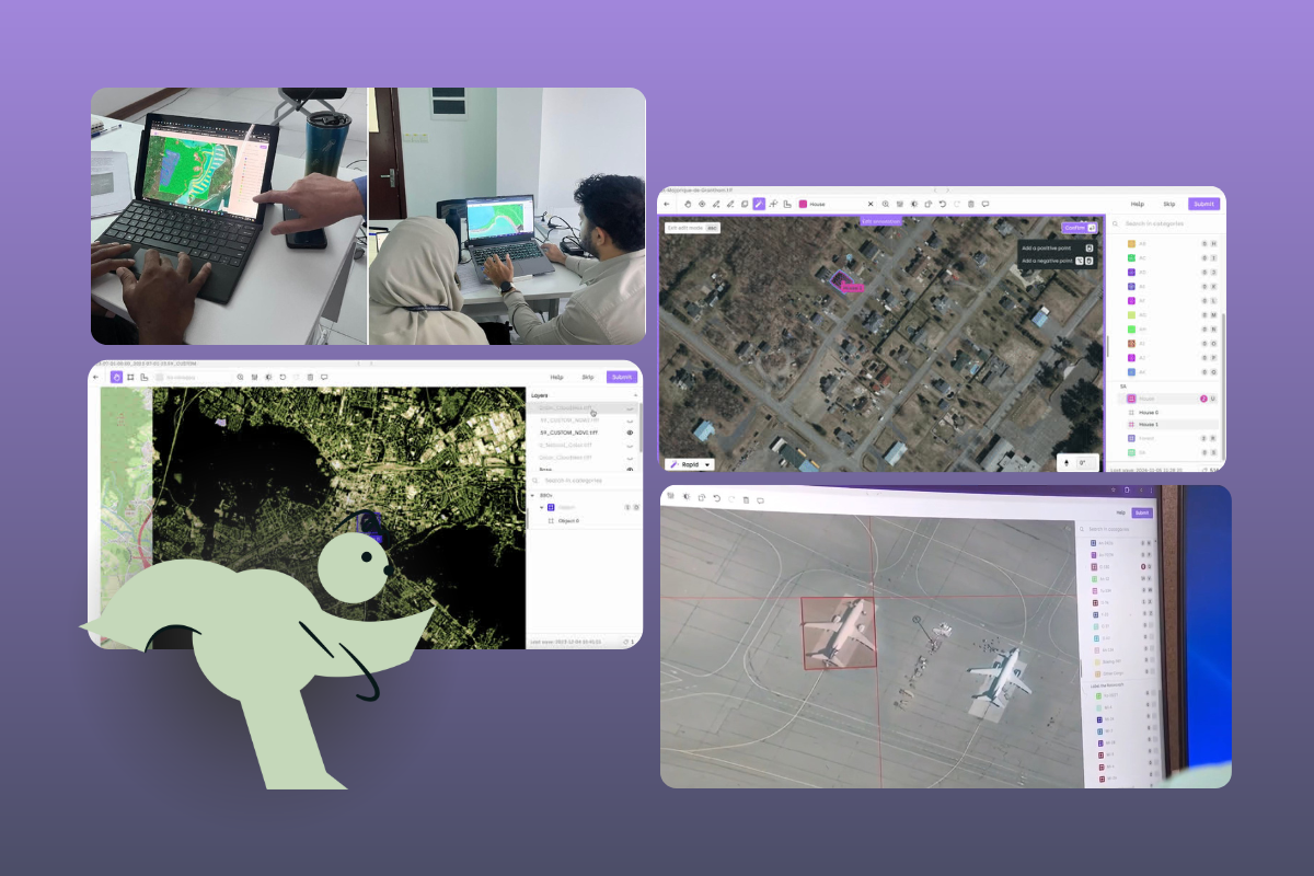
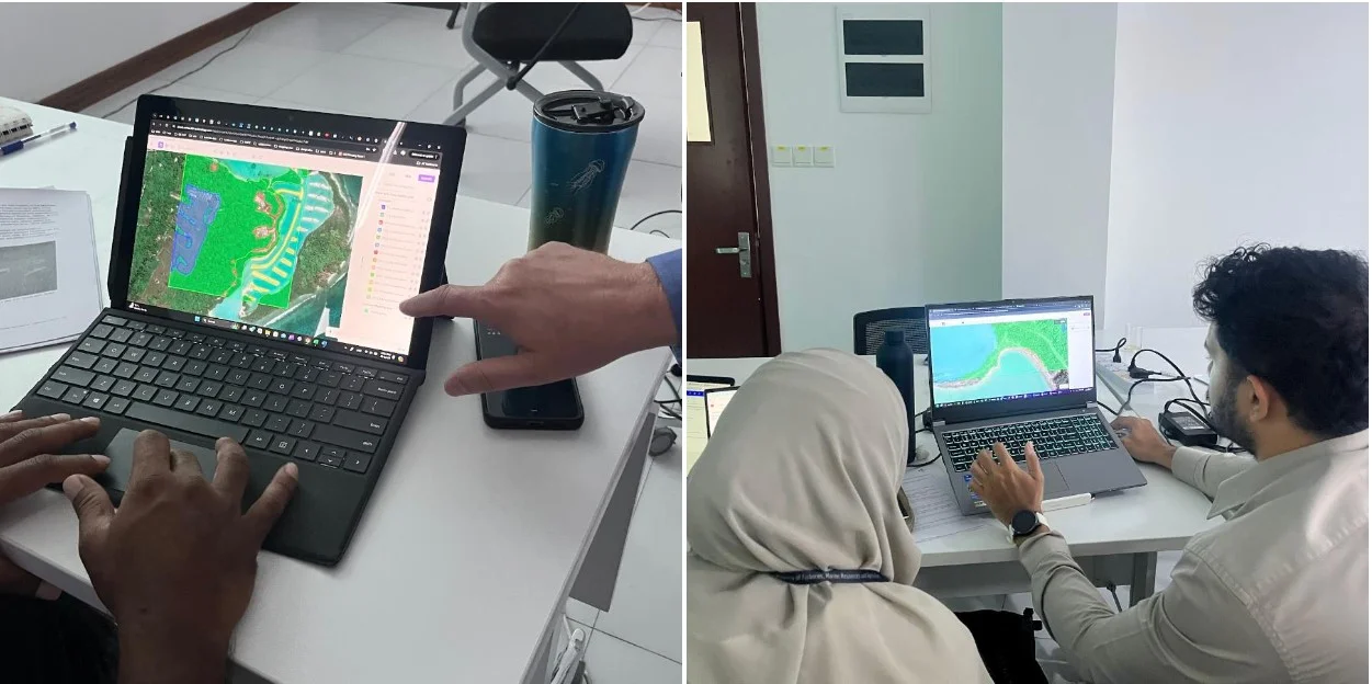
An image of the annotator's working on Kili Technology's annotation tool for the Atlas project. Read the full story: here.
✅ Strict Adherence to High-Quality Annotation Standards – Kili Technology provided a structured annotation workflow, ensuring precision and consistency across different geospatial data types.
✅ Scalable AI-Powered Mapping – Kili’s platform facilitated the seamless processing of large and complex datasets, making it possible to create a scalable, AI-driven global mapping tool.
✅ Human-in-the-Loop Verification for Accuracy – The annotation process incorporated expert review mechanisms, refining AI-generated labels and improving the reliability of ecosystem classifications.
✅ Standardized Data Annotation Across Sources – The ability to integrate satellite and drone imagery allowed researchers to maintain consistency in labeling across varying spatial resolutions.
During the project’s kickoff workshop, Mark Otterlee from AI2 emphasized the critical role of high-quality image annotation in training AI models for ecosystem mapping. By leveraging Kili Technology, researchers and environmental planners now have access to a highly accurate, scalable, and AI-powered mapping tool, setting a new standard for spatial planning, conservation strategies, and biodiversity monitoring in the Maldives and beyond.
Powering the Future of Geospatial Data
Through its advanced geospatial annotation tools, Kili Technology empowers organizations to efficiently produce high-quality labeled data. Whether supporting defense operations with precise intelligence data or driving environmental conservation through AI-powered mapping, Kili’s platform is at the forefront of geospatial innovation.
By streamlining annotation workflows, integrating AI-driven automation, and ensuring seamless compatibility with geospatial workflows, Kili Technology is setting a new standard in geospatial data labeling—one that enables industries to make more informed, data-driven decisions at scale.
Ready to transform your geospatial data workflows? Contact us today to see how Kili Technology can elevate your geospatial annotation capabilities and accelerate your AI-driven insights.
![Best On-Premise Data Labeling Platforms for Regulated Industries [2026] Guide](https://cdn.prod.website-files.com/68da32b2041c593b0511a582/6a574849a90d08dc8b9b547d_Competitor%20Article%20-%20Listicle%201%20(2).webp)