.png)

_logo%201.svg)


AI Summary
The field of Earth Observation (EO) is experiencing unprecedented growth, with an exponential increase in satellite data availability from various missions. This wealth of information offers transformative potential across numerous applications—from disaster management and climate monitoring to urban planning and agriculture. Tools and services like the Copernicus Sentinel-5P Mapping Portal provide valuable data on air pollutant concentrations and track changes in emissions influenced by events such as fires and volcanic eruptions, offering critical insights into the atmosphere and air quality. However, realizing the full potential of this data revolution requires overcoming significant hurdles in data preparation, particularly in creating high-quality labeled datasets for training machine learning models.
Introduction to Earth Observation
Earth observations refer to the systematic collection, analysis, and presentation of data to better understand our planet. This can be achieved through various means, including remote sensing satellites, ground-based measurements, and other advanced technologies. The data gathered from these sources is invaluable for supporting sustainable development, mitigating climate change, and managing disasters. Organizations like the European Space Agency (ESA) and NASA play a crucial role in providing access to this data, enabling decision-makers, researchers, and the private sector to make informed decisions and take effective actions. By leveraging earth observation data, we can gain critical insights into the health of our planet, monitor environmental changes, and develop strategies to address global challenges.
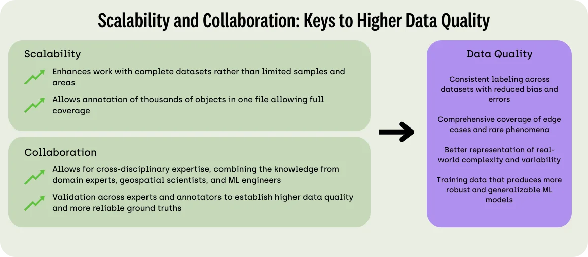
The Shift to Data-Centric AI in Earth Observation
As Andrew Ng noted, “The dominant paradigm over the last decade was to download the data set while you focus on improving the code. (…) It’s now more productive to hold the neural network architecture fixed, and instead find ways to improve the data.” This shift toward data-centric AI places enormous importance on the quality and accuracy of labeled training datasets, especially in the specialized domain of geospatial imagery.
Machine learning engineers working with EO data face unique challenges that set geospatial annotation apart from other data labeling tasks. The complexity of Earth’s surface features, the technical characteristics of satellite sensors, and the sheer volume of data being generated daily all contribute to making satellite imagery annotation particularly demanding. Providing useful information derived from these complex data sets related to climate and environmental changes is crucial. This ensures that actionable insights are accessible, especially for communities lacking specialized knowledge in geospatial fields.
Types of Data
Earth observation data comes in various forms, each serving unique purposes. Satellite imagery, for instance, is instrumental in monitoring air quality, tracking climate change, and predicting weather forecasts. Remote sensing satellites can map land use, identify deforestation areas, and monitor the extent of sea ice. Sensor data, collected from both satellites and ground-based instruments, provides detailed measurements of atmospheric conditions, soil moisture, and other environmental parameters. Ground-based measurements complement satellite data by offering high-resolution, localized information. Together, these diverse data types support sustainable development goals, such as reducing greenhouse gas emissions and promoting sustainable agriculture. The World Economic Forum has highlighted the importance of investing in earth observation data to drive sustainable development and address global environmental challenges.
Accessing and Utilizing Satellite Data
Accessing and utilizing satellite data is essential for supporting sustainable development and climate change mitigation. Various tools and platforms provide free access to this data, such as the European Space Agency’s Copernicus program and NASA’s Earthdata platform. These platforms offer a wide range of data and services, including satellite imagery, sensor data, and analysis tools. Decision-makers, researchers, and the private sector can leverage these resources to inform their decisions and actions. For example, satellite data can be used to monitor floods, track forest fires, and predict weather forecasts, providing critical information for disaster management and environmental monitoring. By utilizing these tools, stakeholders can make data-driven decisions that promote sustainability and resilience.
The Four Vs of Big EO Data

One of the most significant barriers to effective Earth Observation data analysis is the sheer magnitude and complexity of satellite imagery, often characterized through the framework of the "four Vs":
- Volume: Contemporary satellite systems produce data at rates measured in terabytes per day, with archival repositories already containing petabytes of information and projected to grow dramatically in the coming years.
- Velocity: Beyond just volume, the rapid rate at which new data arrives creates significant processing challenges, necessitating near-real-time processing for time-sensitive applications, such as emergency response.
- Variety: EO data encompasses a highly diverse ecosystem of information sources with varying spatial resolutions, temporal frequencies, spectral bands, and file formats, creating substantial obstacles for integration and comparison.
- Veracity: Raw satellite imagery is susceptible to numerous quality issues stemming from sensor imperfections, atmospheric conditions, geometric distortions, and processing artifacts, which can significantly impact its reliability.
Precision and Efficiency
Annotating satellite imagery requires exceptional precision to accurately capture diverse and complex features. Unlike everyday photographs, satellite imagery contains specialized geographical information and often requires domain expertise to interpret correctly. Without access to geographic coordinate systems, distance measurements, or tools designed specifically for geospatial contexts, annotators may struggle to accurately identify and label features of interest, such as the biggest challenges of satellite imagery.
Multi-Spectral Capabilities
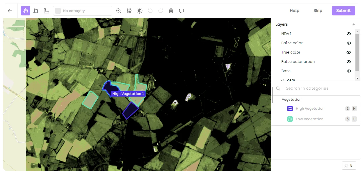
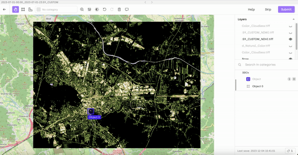
One of the most powerful but challenging aspects of Earth Observation data is its multi-spectral nature. Unlike standard RGB photography, satellite sensors capture information across numerous wavelength bands, including those outside the visible spectrum. Working with multi-spectral imagery presents significant challenges for annotation workflows, as annotators must be able to view and switch between different spectral bands to identify features that may be apparent in one wavelength but not in others.
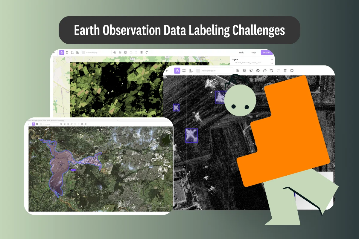
Quality Control for Geospatial Data
Creating high-quality training datasets for Earth Observation applications presents unique quality control challenges. The complexity and diversity of Earth's surface features can make it difficult to establish consistent annotation guidelines and ensure adherence across annotation teams. Ensuring that annotations are correctly geolocated is crucial, especially for applications requiring precise location data, such as urban planning or disaster response.
Team Collaboration
Effective collaboration represents a significant challenge in Earth Observation projects, which often involve diverse stakeholders including government agencies, research institutions, non-governmental organizations, private sector entities, and various industries. Collaboration among these sectors and industries is crucial to leverage Earth observation technologies for sustainable development and economic growth. Technical incompatibilities, restrictive data policies, intellectual property concerns, governance issues, trust barriers, and resource gaps all contribute to a fragmented ecosystem that impacts the quality and efficiency of annotation efforts.
Data Security and Privacy Compliance
The rapid advancement of satellite imaging technology presents significant security and privacy considerations. Commercial satellite operators are continuously improving the spatial resolution of their imagery, raising concerns about surveillance and the erosion of personal privacy. Beyond privacy concerns, EO data and the complex systems that process it are increasingly attractive targets for cyberattacks, requiring robust security measures.
Solutions for Effective Geospatial Annotation
Specialized Tools for Scale
Specialized geospatial annotation platforms address these challenges through purpose-built features like image tiling for large geospatial files, which automatically divides large images into smaller, manageable tiles. Enhanced memory management loads only annotations visible within the current viewport, resulting in a more seamless navigation experience, especially when dealing with dense, complex annotations.
Enhanced Precision Features
Modern platforms offer key precision-enhancing features including native support for Coordinate Reference Systems (CRS), GPS coordinate extraction, distance measurement tools, and support for various annotation methods including polygons, bounding boxes, and lines. These capabilities can be further enhanced by integration with advanced foundation models like SAM2 (Segment Anything Model 2).
Multi-Spectral Support
Advanced geospatial annotation platforms support specialized formats like GeoTIFF, Tiff, JP2, and NITF, with multi-layer interfaces allowing visualization and annotation across different spectral bands. The ability to toggle between spectral layers while maintaining annotation context is crucial for identifying features that may only be visible in specific bands.
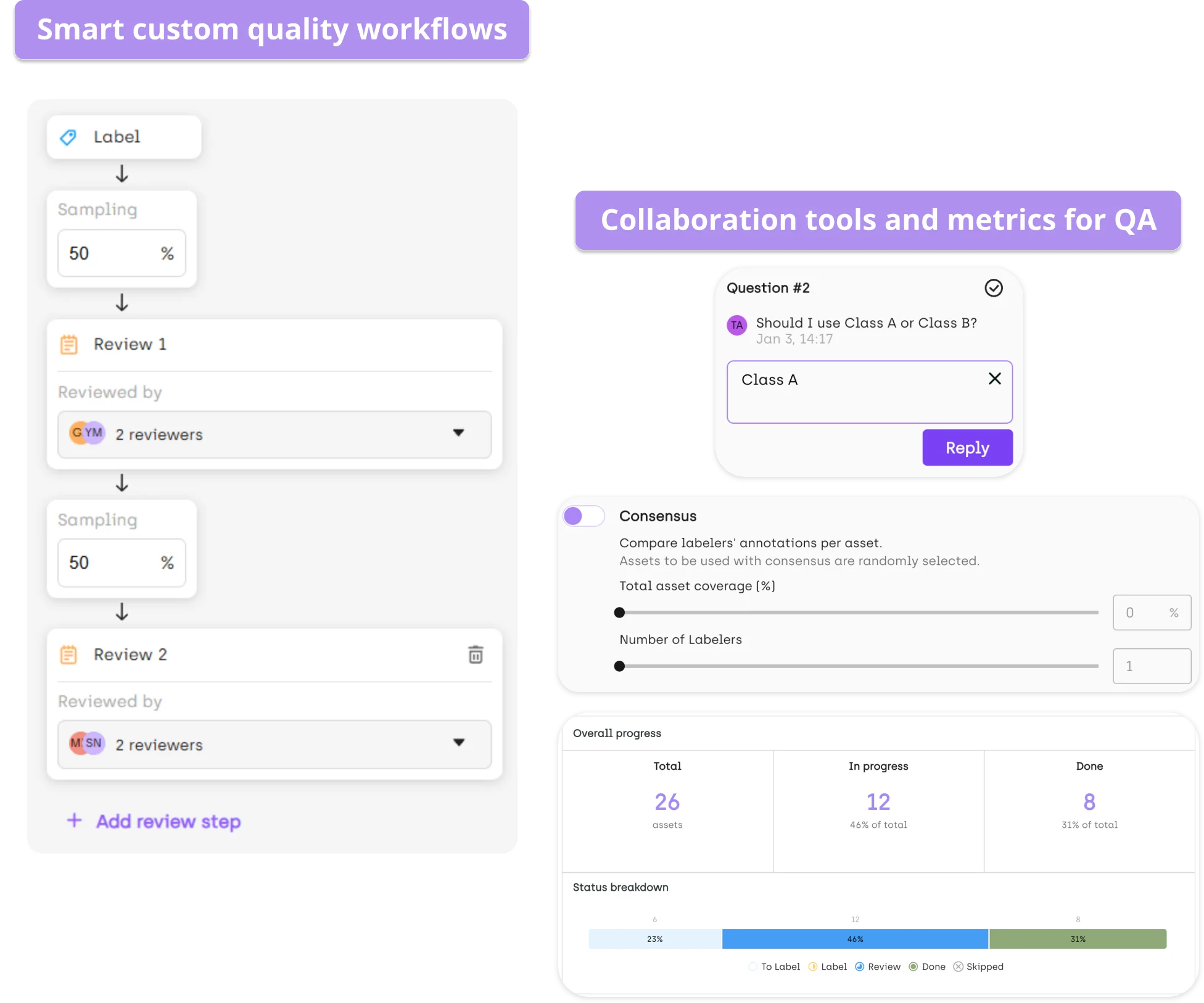
Quality Assurance Mechanisms
Specialized platforms implement honeypot and consensus features to measure annotator performance, programmatic quality assurance workflows through API access, advanced filtering for focused reviews, and comprehensive metrics tracking both quality and productivity to provide valuable insights into the annotation process.
Collaboration Features
Key collaboration capabilities include role-based permissions management, shared workspaces with real-time progress monitoring, and adjustable interfaces to accommodate different team members' needs and expertise levels. These features significantly improve the efficiency and quality of geospatial annotation projects.
Security and Compliance

Flexible deployment options (SaaS, hybrid, or on-premise), advanced access management with strong authentication and role-based controls, and security certifications like ISO 27001 and SOC2 enable organizations to balance collaborative annotation with data protection and regulatory compliance.
ML Workflow Integration
API access for automation and integration, support for model-generated pre-annotations, and geospatially-aware export capabilities ensure that when annotations are exported for model training or analysis, critical geographic context is preserved.
Real-World Applications of Geospatial Annotation
Specialized geospatial annotation platforms are transforming how organizations extract value from Earth Observation data. Here are several compelling examples of how these technologies are being applied to solve real-world challenges:
Building Damage Assessment Following Natural Disasters
The xBD dataset project demonstrates the power of well-annotated geospatial data for disaster response. This landmark initiative created a comprehensive benchmark dataset for assessing building damage from various natural disasters (floods, fires, earthquakes, windstorms) across multiple countries.
Key Challenges:
- Processing vast amounts of high-resolution satellite imagery covering thousands of square kilometers
- Identifying and labeling individual buildings across diverse architectural styles
- Developing standardized methods for assessing damage levels consistently across different disaster types
- Addressing class imbalance issues where certain damage categories were underrepresented
Solutions and Impact:
- Development of the standardized "Joint Damage Scale" to enable consistent annotation
- Implementation of specialized resampling strategies (MLOS, DAC, DAM, SMOTE) to tackle class imbalance
- Creation of methods to convert between pixel-level and building-level metrics for comparing different approaches
- The resulting dataset has become a valuable benchmark that has advanced automated disaster damage assessment
This application directly supports faster, more accurate disaster response by enabling AI systems to rapidly identify damaged structures and prioritize humanitarian aid following catastrophic events.
Defense Applications Requiring High-Precision Geospatial Intelligence
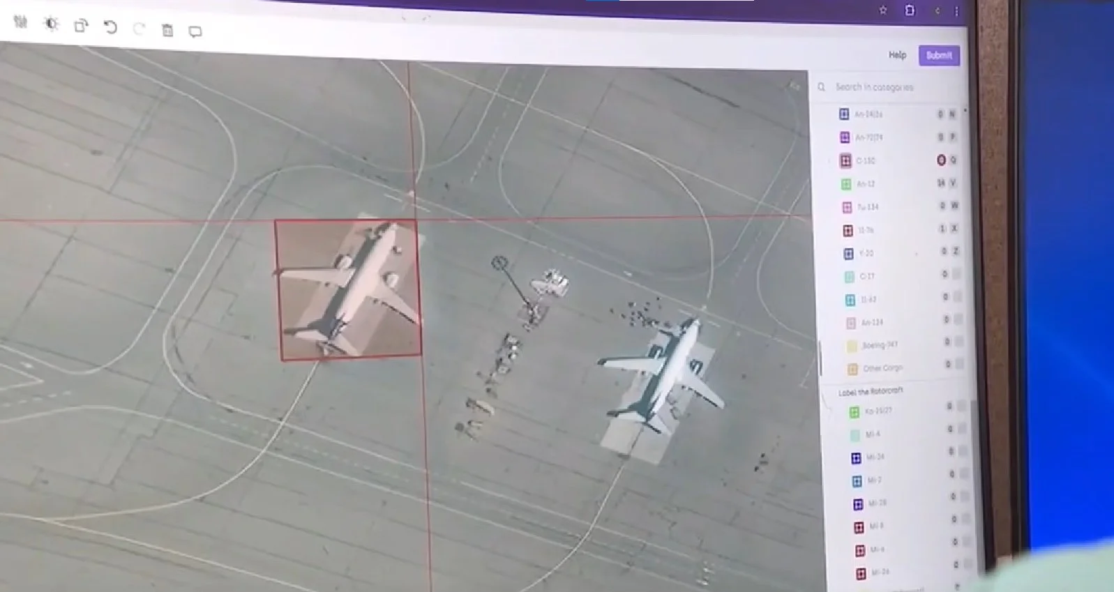
Defense organizations face particularly demanding requirements for geospatial annotation, as demonstrated by Enabled Intelligence's work providing labeled datasets for U.S. defense applications.
Key Challenges:
- Need for extremely precise annotations at varying levels of detail
- Handling specialized data types including hyperspectral imagery, SAR (Synthetic Aperture Radar), and electro-optical imagery
- Stringent security requirements for sensitive intelligence data
- Necessity for human verification in mission-critical contexts
Solutions and Impact:
- Implementation of geolocalized data capabilities and advanced measuring tools for tactical intelligence
- Scalable processing of massive satellite and aerial imagery files
- Multi-modal annotation across different sensor types enabling material identification in low-visibility conditions
- Integration of expert review mechanisms for mission-critical accuracy verification
These applications enhance national security capabilities through improved threat assessment, resource allocation, and operational planning while maintaining the highest standards of data security.
Ecosystem Mapping for Conservation Planning
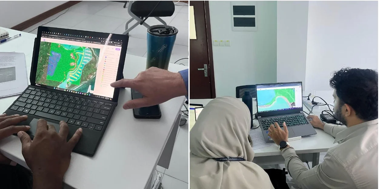
The Global Ecosystems Atlas project represents a groundbreaking initiative focused on comprehensive, high-resolution mapping of ecosystems, with the Maldives serving as a pilot region. This project emphasizes the importance of monitoring and analyzing various environmental factors and changes to better understand and safeguard our environment.
Key Challenges:
- Integrating and analyzing multi-source satellite and drone imagery with varying resolutions
- Distinguishing subtle differences between ecosystem types
- Implementing standardized classification across different geospatial data sources
- Processing large volumes of data for comprehensive environmental mapping
Solutions and Impact:
- Precise classification of complex marine, terrestrial, and freshwater ecosystems
- Implementation of structured annotation workflows ensuring scientific validity
- Use of AI-powered mapping with expert human verification to balance efficiency and accuracy
- Creation of scalable mapping tools that can be extended beyond the initial pilot region
This work provides critical data for conservation planning, environmental management, and biodiversity monitoring, creating a blueprint for similar ecosystem mapping efforts worldwide.
Agricultural Crop Monitoring with Multi-Spectral Data
Agricultural technology companies have leveraged multi-spectral satellite imagery annotation to develop sophisticated crop monitoring solutions. These initiatives not only enhance agricultural productivity but also align with the United Nations sustainable development goals by promoting sustainable economic growth and contributing to affordable and clean energy. By protecting natural capital, these technologies reflect a dual-value potential that supports both environmental and economic objectives.
Key Challenges:
- Identifying crop health indicators and pest stress visible only in specific non-visible spectral bands
- Processing large volumes of high-resolution imagery covering diverse geographic regions and crop types
- Annotating seasonal changes and temporal patterns in agricultural landscapes
- Creating training data that accounts for regional variations in farming practices
Solutions and Impact:
- Utilization of different spectral bands to identify subtle differences in crop health
- Implementation of semi-automated annotation using foundation models to accelerate field boundary detection
- Establishment of robust quality control through consensus review among agricultural experts
- Development of models achieving over 90% accuracy in crop type identification
These applications have enabled early detection of pest infestations before visible symptoms appear, allowing farmers to implement targeted interventions and reduce pesticide use by approximately 30%. The resulting systems support precision agriculture, enhance sustainability, and improve crop yields through proactive management.
Urban Infrastructure Mapping for Smart City Planning
Municipal governments have employed specialized geospatial annotation to create comprehensive maps of urban infrastructure supporting smart city initiatives.
Key Challenges:
- Coordinating input from diverse stakeholders, including urban planners, civil engineers, transportation specialists, and environmental experts
- Annotating complex, overlapping infrastructure elements in densely populated areas
- Maintaining spatial accuracy is essential for planning applications
- Ensuring consistent annotation standards across different infrastructure types
Solutions and Impact:
- Implementation of role-based access control to coordinate expert input
- Utilization of specialized annotation tools for different infrastructure types (polygons, lines, points)
- Leveraging GPS coordinate extraction and distance measurement tools for accurate spatial relationships
- Integration of annotation data with existing GIS systems through geospatially-aware exports
These efforts have enabled the development of AI models that automate infrastructure detection and classification from new satellite imagery, reducing mapping time by approximately 70% and improving decision-making for urban development projects.
Future Directions
As Earth Observation technologies continue to evolve, the field of geospatial annotation will advance with deeper integration between AI and EO, enhanced multi-modal capabilities, edge computing and in-orbit processing approaches, and improved digital twin integration. Several key trends are shaping the future of this domain:
1. Integration with AI4EO Initiatives
The European Space Agency’s Φ-lab focus on advancing AI for EO (AI4EO) represents a growing trend toward deeper integration between artificial intelligence and Earth Observation. This integration supports climate action by addressing environmental challenges through the combined efforts of nature and technology, promoting sustainable economic growth. Future annotation platforms will likely incorporate more sophisticated AI capabilities, including improved foundation models specifically trained for geospatial data and domain-specific pre-trained models for common EO tasks.
2. Bridging the Digital Divide
Addressing capacity and resource gaps, particularly for organizations in developing nations or smaller research groups, remains a critical challenge. Future platforms will need to focus on accessibility, providing simplified interfaces and cloud-based solutions that reduce the technical barriers to entry while maintaining advanced capabilities for expert users.
3. Enhanced Multi-Modal Integration
As satellite sensors continue to diversify, annotation platforms will need to support an increasingly wide range of data modalities. This includes integrating traditional optical imagery with SAR (Synthetic Aperture Radar), LiDAR, hyperspectral, and thermal data within unified annotation workflows.
4. Edge Computing and In-Orbit Processing
Emerging paradigms, such as edge computing and in-orbit processing, promise to transform how satellite data is processed and analyzed. These approaches may enable preliminary annotation or feature extraction to be performed directly on satellites or edge devices, thereby reducing the volume of data that needs to be transmitted and processed centrally.
5. Advanced Privacy-Enhancing Technologies
Future annotation platforms are likely to incorporate more sophisticated privacy-enhancing technologies, such as differential privacy and secure multi-party computation, to strike a balance between data utility and privacy protection. These technologies will be particularly important as the resolution and frequency of satellite observations continue to increase.
Conclusion
The Earth Observation landscape is undergoing a profound transformation, driven by an exponential increase in data availability and advancements in processing technologies. However, realizing the immense potential of EO data for scientific discovery, environmental stewardship, economic development, and societal well-being hinges on overcoming significant challenges in data labeling and preparation for machine learning applications.
Specialized annotation platforms address these challenges through purpose-built features explicitly designed for geospatial data. From tackling the scalability requirements of massive satellite imagery to enabling precise annotation with geographic context, supporting multi-spectral analysis, implementing robust quality control, facilitating team collaboration, ensuring security and compliance, and integrating with broader ML workflows, these platforms provide comprehensive solutions for Earth Observation professionals.
For machine learning engineers and data scientists working with Earth Observation data, staying abreast of developments and adopting evolving best practices is essential. By embracing specialized tools designed for the unique challenges of geospatial data, organizations can maximize the value of Earth Observation while addressing the technical and ethical complexities inherent in this rapidly evolving field.
Take action now
Ready to transform your Earth Observation ML workflows? Download our comprehensive "Addressing Earth Observation Data Labeling Challenges" report for an in-depth exploration of solutions, case studies, and best practices that can help your team overcome the unique challenges of geospatial annotation. Take the first step toward unlocking the full potential of satellite imagery for your machine learning projects today!
See our geospatial annotation platform in action. Our team of experts is ready to demonstrate how Kili Technology's specialized tools can address your specific Earth Observation challenges. From handling massive satellite imagery datasets to implementing multi-spectral analysis and ensuring precise annotations, we'll show you how our platform can accelerate your machine learning workflows. Book a personalized demo today to explore how we can help you create high-quality training datasets for your geospatial AI projects.
![Best On-Premise Data Labeling Platforms for Regulated Industries [2026] Guide](https://cdn.prod.website-files.com/68da32b2041c593b0511a582/6a574849a90d08dc8b9b547d_Competitor%20Article%20-%20Listicle%201%20(2).webp)